4 entries match your criteria.
Related Historical Markers
Trace the path of the expidition by way of markers.
By J. J. Prats, September 19, 2009
Skinner’s Neck and Windsor Markers
SHOWN IN SOURCE-SPECIFIED ORDER
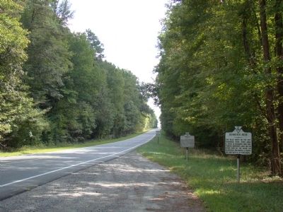
| On U.S. 17, 0.5 miles south of Ware Creek Road, on the right when traveling south. |
| | This is the ancient Woodford Estate. Governor Spotswood and the Knights of the Golden Horseshoe stopped here on their way to the mountains, August, 1716. Here General William Woodford was born, October 6, 1734. He defeated Governor Lord Dunmore at . . . — — Map (db m22577) HM |
| On Germanna Highway (Virginia Route 3) at College Drive (Virginia Road 375), on the right when traveling east on Germanna Highway. |
| | Here Governor Alexander Spotswood established a colony of Germans in 1714. At that time the Rapidan River was the frontier of Virginia. On August 29, 1716, Spotswood left from this place with the Knights of the Golden Horseshoe on his exploring . . . — — Map (db m171387) HM |
| On James Madison Highway (U.S. 15) at Madison Mills Lane, on the right when traveling north on James Madison Highway. |
| | Near here Governor Alexander Spotswood and his troop of gentlemen, Knights of the Golden Horseshoe, on their way to explore the land beyond the mountains, camped on August 31, 1716. — — Map (db m4705) HM |
| On Spotswood Trail (U.S. 33) at Skyline Drive, on the right when traveling east on Spotswood Trail. |
| | On 5 Sept. 1716, in this region, it is believed, Lieutenant Governor Alexander Spotswood and his party of government officials, gentry, Native Americans, soldiers, and servants crossed the Blue Ridge Mountains into the Shenandoah Valley. Their . . . — — Map (db m1842) HM |
Apr. 30, 2024