4 entries match your criteria.
Related Historical Markers
To better understand the relationship, study each marker in the order shown.
By Mike Stroud, 2003
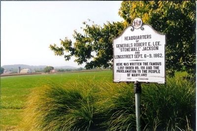
Headquarters of Generals Robert E. Lee Marker
SHOWN IN SOURCE-SPECIFIED ORDER
| On Urbana Pike (Maryland Route 355) at New Technology Way, on the right when traveling east on Urbana Pike. |
| | Here was written the famous lost order No. 191 and the proclamation to the people of Maryland. — — Map (db m155658) HM |
| On Reno Monument Road at the Appalachian Trail, on the left when traveling west on Reno Monument Road. |
| | On September 4, 1862, General Robert E. Lee, hoping to shorten the war by winning a decisive victory on Northern soil, crossed the Potomac River into Maryland. Lee planned to draw the Army of the Potomac through South Mountain into Pennsylvania and . . . — — Map (db m2041) HM |
| On Reno Monument Road at the Appalachian Trail, on the left when traveling west on Reno Monument Road. |
| |
No other document of the Civil War has generated so much controversy as Lee's Special Orders No. 191. These “Lost Orders” detailed the movements of Lee's army for the operation against Harpers Ferry. On September 9 Lee sent copies of the order to . . . — — Map (db m2042) HM |
| On Gapland Road at Arnoldstown Road, on the left when traveling west on Gapland Road. |
| | (Left Side) On September 4, 1862, General Robert E. Lee, hoping to shorten the war by winning a decisive victory on Northern soil, crossed the Potomac River into Maryland. Lee planned to draw the Army of the Potomac through South Mountain into . . . — — Map (db m2039) HM |
May. 7, 2024