5 entries match your criteria.
Related Historical Markers
To better understand the relationship, study each marker in the order shown.
By Alan Edelson, February 25, 2009
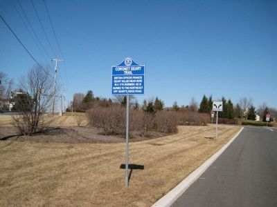
Coronet Geary Trail Marker
SHOWN IN SOURCE-SPECIFIED ORDER
| On U.S. 202 at Cornet Way, on the right when traveling north on U.S. 202. |
| | British officer Francis Geary killed near here in a 1776 skirmish. He is buried to the northeast off Geary’s Ridge Road. — — Map (db m16735) HM |
| On U.S. 202 at milepost 8, on the right when traveling north. |
| | Near here British cavalry were routed by Capt. John
Schenck's militia Dec. 1776. British Geary was killed and buried on field. — — Map (db m182796) HM |
| On Old York Road (New Jersey Route 613 at milepost 1.2), on the right when traveling north. |
| | Early Lenape Indian trail; became a "Kings Highway" in 1764. Was main stage route between Philadelphia and New York. — — Map (db m62457) HM |
| On Durham Road near Philadelphia Road, on the right when traveling north. |
| | :In the 1700's, Robert Durham built his historical boat in Durham, Pa. These boats were used to ship cannon balls, made at the Durham Furnace, to Philadelphia during the Revolutionary War. On Christmas Eve, in 1776, Washington and his men crossed . . . — — Map (db m21785) HM |
| On New Jersey Route 202, on the right when traveling north. |
| | Erected in memory of the citizen soldiers of Amwell Township who, commanded by Captain John Schenck, on December 14th 1776, met and drove from this field a column of the British 16th Light Dragoons, after killing their commander, Cornet Francis . . . — — Map (db m31959) HM |
May. 3, 2024