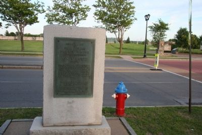
On North James Street (New York State Route 26) at West Dominick Street, on the right when traveling south on North James Street.
Here Aug. 3, 1777
the
Stars & Stripes
First Flew In Battle
Above the Southwest Bastion
of
Fort Stanwix
(Schuyler)
Here Aug 2d to 22d Col. Peter Gansevoort's New York & Massachusetts Continentals successfully . . . — — Map (db m32402) HM
Near North James Street (New York State Route 26) east of West Dominick Street.
The outcome of the American Revolution, and the opening of the West during both wartime and peace, hinged upon events at this gateway between East and West.
Walk the Oneida Carrying Place
Rediscover this trail between East and West . . . — — Map (db m33310) HM
On North James Street south of West Dominick Street.
For centuries water was the easiest way to move people, goods, and ideas. Hundreds of tons of trade goods passed over the Oneida Carrying Place — here raw materials sent east from the Great Lakes region passed manufactured goods heading west. . . . — — Map (db m32584) HM
Near North James Street south of West Dominick Street.
For centuries American Indians, traders, soldiers, and travelers crossed over this very path. Here goods and ideas were exchanged.
The name of this portage trail between two river systems is the "Oneida Carrying Place." It served as a major . . . — — Map (db m32662) HM
Near North James Street (New York State Route 26) east of Erie Boulevard East (New York State Route 49).
Fort Stanwix is best known for the 1777 siege, but such dramatic events were not a feature of everyday life here.
Limited space inside the fort forced some soldiers and a few of their wives and children to live outside the walls. A unique . . . — — Map (db m33285) HM
Near Black River Boulevard North (New York State Route 46) at East Dominick Street (New York State Route 49).
Built on the foundation of the original 18th-century fort, this reconstruction provides insight into the experiences of those who lived here.
Their stories are preserved in recreated rooms, barracks, and exhibits.
Their stories are told . . . — — Map (db m33286) HM
Near Black River Boulevard North (New York State Route 46) west of East Dominick Street (New York State Route 49).
Fort Stanwix...is large and well situated. The Examination of this fortification gave me a better idea of the strength and Importance of a Fort than any thing I ever before saw or Read.
Captain Joseph Bloomfield, 1776 — — Map (db m33300) HM
On Black River Boulevard North (New York State Route 46) north of East Dominick Street (New York State Route 49).
The spring-fed stream, reconstructed here, supplied the garrison with water for drinking and washing. Extending out from the fort was an elevated latrine called a "necessary." It ran into a short channel that fed downstream to the fort's garden. . . . — — Map (db m32417) HM
The British gun battery of four cannons and four mortars was located near the brick-red high rise building you see today in front of you. These relatively small weapons were unable to cause significant damage to the fort.
British commander . . . — — Map (db m32705) HM
On North James Street (New York State Route 26) at Liberty Street, on the left when traveling south on North James Street.
During the August 1777 Siege of Fort Stanwix, British forces dug trenches near this site. This attempt to bring their guns closer to the fort's powder magazine, located in the bastion in front of you, failed.
At the end of the three-week siege, . . . — — Map (db m32485) HM