Near Mechanicsville in Hanover County, Virginia — The American South (Mid-Atlantic)
The Battle Ends
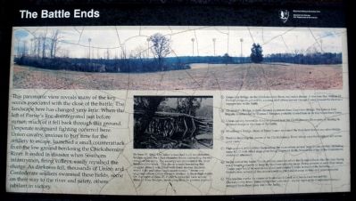
(A) Grapevine Bridge on the Chickahominy River, two miles distant. It was here that William H. French’s brigade, piloted by a young staff officer named George Custer, crossed the river as a support late in the battle.
(B) Alexander’s Bridge, a short distance upstream from Grapevine Bridge. The famous Irish Brigade, commanded by Thomas F. Meagher, probably crossed here on its way to reenforce Porter.
(C) Union cavalry formed in this low ground near the Chickahominy River prior to making its ill-fated charge at the close of the battle.
(D) Woodbury’s Bridge. More of Porter’s men recrossed the river here than at any other bridge.
(E) Treeline denoting the course of the Chickahominy River, which runs from right to left across your view.
(F) High ground at Gouldin’s Farm across the river where several large Union cannon, including some 4-1/2 inch rifled siege guns firing 25-pound shells, blasted the edge of the Confederate attacks all afternoon.
(G) At the end of the battle, union artillery established on knolls and hillcocks like this one, facing west, fought valiantly to keep Southern infantry away. Firing canister at very close range, “Large gaps could be seen in his [the Confederates’] ranks in front of the batteries…” Nonetheless, several of the cannon could not be hauled away in time and were captured.
(H) This treeline marks the course of Boatswain’s Creek as it bends back toward the Chickahominy River. James Longstreet’s division-the far right of the Confederate army-emerged from those tree late in the battle.
Erected by National Park Service.
Topics. This historical marker is listed in this topic list: War, US Civil.
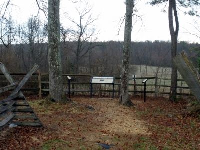
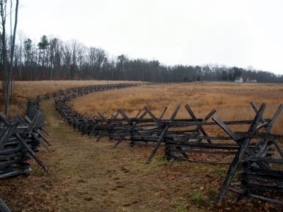
Location. This marker has been replaced by another marker nearby. It was located near 37° 34.29′ N, 77° 17.7′ W. Marker was near Mechanicsville, Virginia, in Hanover County. Marker could be reached from Watt House Road, 0.7 miles south of Cold Harbor Road (Virginia Route 156), on the right when traveling south. This marker is located on the walking trail along Boatswain Creek in the Gaines' Mill Battlefield unit of the Richmond National Battlefield Park. Touch for map. Marker was in this post office area: Mechanicsville VA 23111, United States of America. Touch for directions.
Other nearby markers. At least 8 other markers are within walking distance of this location. Balloons Over the Battlefield (here, next to this marker); Mistaken Identity (a few steps from this marker); The Cavalry Charge (a few steps from this marker); Watt Farm Road (about 500 feet away, measured in a direct line); Union Rifle Pits (about 500 feet away); Wilcox’s Alabama Brigade, (about 600 feet away); Intensity of Battle (about 600 feet away); Wilcox’s Brigade, CSA (about 700 feet away). Touch for a list and map of all markers in Mechanicsville.
More about this marker. On the top of the panel is a panorama of the Chickahominy River landscape describing key features of the battlefield (see text above).
In the center is a period photo of a military bridge over the Chickahominy River with the caption, "By June 17, 1862, McClellan’s men had built ten different bridges across the Chickahominy River, connecting the two wings of the army. The swampy environment of the river hindered the work. “The dense woods bordering this sluggish stream was filled with black snakes, lizards, wood ticks and other unpleasant vermin,” wrote one engineer officer. Often the men worked in chest-high water. On the night of June 27, Porter’s forces fell back across three of those bridges, destroying them to prevent pursuit."
Related marker. Click here for another marker that is related to this marker. Old Marker At This Location titled "Balloons Over the Battlefield".
Also see . . .
1. CWSAC Battle Summary. Gaines’ Mill (Submitted on February 23, 2009, by Bernard Fisher of Richmond, Virginia.)
2. Gaines’ Mill Podcast. 8-stop, 1.5-mile walking tour narrated by NPS historian, Robert Krick. (Submitted on February 23, 2009, by Bernard Fisher of Richmond, Virginia.)
Credits. This page was last revised on November 5, 2021. It was originally submitted on February 23, 2009, by Bernard Fisher of Richmond, Virginia. This page has been viewed 1,185 times since then and 13 times this year. Photos: 1, 2, 3, 4. submitted on February 23, 2009, by Bernard Fisher of Richmond, Virginia.


