2 entries match your criteria.
Related Historical Markers
By Brian Scott, June 20, 2008
Cherokee Boundary (1767) Marker - Reverse Side
SHOWN IN SOURCE-SPECIFIED ORDER
| 1 ► South Carolina, Greenville County, Greer — 23-30 — Cherokee Boundary (1767) — |
| [Front]: In 1766-67 S.C. & N.C. negotiated with the Cherokee to establish a boundary between Indian land to the west and new settlement to the east. This north-south line ran past this point to N.C. and on to Va. In S.C. it ran north . . . — — Map (db m8446) HM | |||
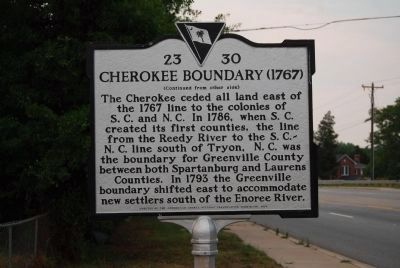
| 2 ► South Carolina, Greenville County, Fountain Inn — 23-30 — Cherokee Boundary (1767) — |
| [Front]: In 1766-67 S.C. & N.C. negotiated with the Cherokee to establish a boundary between Indian land to the west and new settlement to the east. This north-south line ran past this point to N.C. and on to Va. In S.C. it ran north . . . — — Map (db m49086) HM | |||