2 entries match your criteria.
Related Historical Markers
By Brian Scott, June 20, 2008
Cherokee Boundary (1767) Marker - Reverse Side
SHOWN IN SOURCE-SPECIFIED ORDER
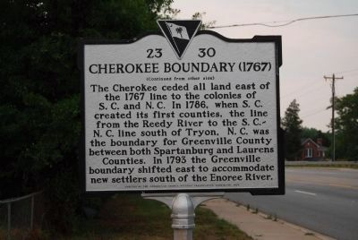
| 1 ► South Carolina, Greenville County, Greer — 23-30 — Cherokee Boundary (1767) — |
| On South Highway 14 (State Highway 14), on the left when traveling north. | |||
| 2 ► South Carolina, Greenville County, Fountain Inn — 23-30 — Cherokee Boundary (1767) — |
| On McCarter Drive (State Highway 418) west of Interstate 385, on the right when traveling west. | |||