4 entries match your criteria.
Related Historical Markers
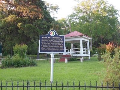
By Cosmos Mariner, May 28, 2013
Town of Gainesville marker
SHOWN IN SOURCE-SPECIFIED ORDER
| On State Street (Alabama Route 116) at McKee Street (Alabama Route 39), on the right when traveling south on State Street. |
| |
The Town of Gainesville, a designated Tree City USA, was founded in 1832. The land on which the town is located was originally owned by John Coleman, husband to a Choctaw Indian of the area. He sold the land to Colonel Moses Lewis, who had the . . . — — Map (db m69709) HM |
| On Natchez Trace Parkway (at milepost 140) at Red Dog Road, on the left when traveling north on Natchez Trace Parkway. |
| | The road to your left, running to Canton, Mississippi, was opened in 1834 and named for Choctaw Indian Chief Ofahoma or Red Dog. Like other Choctaw, he had accepted the way of his European neighbors and had become a farmer.
Chief Ofahoma . . . — — Map (db m87488) HM |
| On Lafayette Street (U.S. 11) at Franklin Street, on the right when traveling south on Lafayette Street. |
| |
1736: First settlement by French at Ft. Tombecbee.
1830: U.S. got Choctaw Indian lands by Treaty of Dancing Rabbit Creek.
1832: County created by Act of State Legislature -- named for Gen. Thomas Sumter, "The Gamecock," South . . . — — Map (db m92663) HM |
| On Washington Street South at Franklin Street, on the right when traveling north on Washington Street South. |
| |
Side 1
Livingston, Alabama
Prior to the signing of the Treaty of Dancing Rabbit Creek on September 27, 1830, this site belonged to the Choctaw Nation. Early settlers to the area came from the Carolinas, Georgia, Tennessee, and . . . — — Map (db m92665) HM |
Apr. 30, 2024