2 entries match your criteria.
Related Historical Markers
To better understand the relationship, study the markers shown.
By Paul Crumlish, June 26, 2011
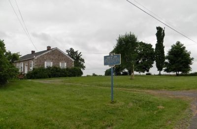
Wide view of the Erected 1834 Marker
SHOWN IN SOURCE-SPECIFIED ORDER
| On Quaker Road, 0.2 miles west of River Road (New York State Route 251), on the left when traveling west. |
| | Quaker Meeting House built and used by the Orthodox Quakers 1834-54 by Hicksites 1854-1873 Grange Hall 1937 — — Map (db m56835) HM |
| On Quaker Road, 0.2 miles east of Bowerman Road (County Road 716), on the right when traveling east. |
| | Quaker Cemetery bought
1833 from Darius Shadbolt — — Map (db m56833) HM |
May. 5, 2024