3 entries match your criteria.
Related Historical Markers
Three of the four corner boundary stones: North, East, and South. Can you find and add the fourth to the database?
By F. Robby, January 28, 2008
Original Federal Boundary Stone North Marker
SHOWN IN SOURCE-SPECIFIED ORDER
| Near East West Highway (Route 410) 0.3 miles west of 16th Street (Route 390), on the right when traveling east. |
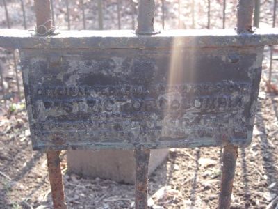
| | Original Federal Boundary Stone
District of Columbia
Placed 1791-1792
Protected by Maryland Chapter
Daughters of the American Revolution
1916 — — Map (db m154844) HM |
| On Eastern Avenue Northeast at Southern Avenue Northeast, on the left when traveling east on Eastern Avenue Northeast. |
| | Original Federal Boundary Stone
District of Columbia
Placed 1791-1792
Protected by Dist. of Co. Chapter
Daughters of the American Revolution
1916 — — Map (db m190187) HM |
| Near South Street near South Washington Street (Virginia Route 400). Reported permanently removed. |
| | . . . — — Map (db m154751) HM |
May. 7, 2024