5 entries match your criteria.
Related Historical Markers
To better understand the relationship, study each marker in the order shown.
By David Seibert, March 28, 2004
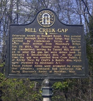
Mill Creek Gap Marker
SHOWN IN SOURCE-SPECIFIED ORDER
| On Old US 41, 0.1 miles east of Rocky Face Railroad Street, on the left when traveling east. |
| | Otherwise known as Buzzard Roost. This natural gateway through Rock Face Ridge, was heavily fortified by Confederate forces at Dalton, after their
retreat from Missionary Ridge.
February 25, 1864, the Federal 14th A.C., Dept. of the Cumberland, . . . — — Map (db m11069) HM |
| On Chattanooga Road (U.S. 41), on the right when traveling south. |
| | Feb. 25, 1864. Stewart’s and Breckinridge’s divs. in the gap, repulsed the attacks of the Federal 14th A.C., from the N.W., while Hindman's A.C. drove back Cruft's and Bard’s divs. in Crow Valley E. of Rocky Face Ridge and N. of the R.R. May 8-9. . . . — — Map (db m19265) HM |
| On U.S. 41, on the left when traveling north on U.S. 41. |
| | The Confederate defenders of Dalton impounded the waters of Mill Creek by a dam, in the gap, as a measure of defense when Federal forces under Sherman assailed this opening in Rocky Face Ridge. This temporary lake, together with fortifications in . . . — — Map (db m10787) HM |
| On Chattanooga Road (U.S. 41) 0.3 miles north of Willowdale Road, on the right when traveling south. |
| | Federal frontal attacks failing completely here Sherman ably outflanked the Confederate army strongly entrenched across Rocky Face ridge and this gap. Whereupon Johnston with great skill reestablished a position by withdrawing to Resaca. — — Map (db m13279) HM |
| On Chattanooga Road (U.S. 41), on the left when traveling south. |
| | High up on Rocky Face, S. of gap, is the lone grave of English-born George Disney, Co. K., 4th Ky. Inft., Lewis' “Orphan Brigade”, Bate’s div., Hindman’s
Corps (CS). The 4th Ky. was deployed to form a living telegraph line from base . . . — — Map (db m11075) HM |
May. 3, 2024