2 entries match your criteria.
Related Historical Markers
By TRCP Alliance, June 22, 2013
Fort Mims And The Creek Indian War, 1813-14 Marker (Reverse)
SHOWN IN SOURCE-SPECIFIED ORDER
| On Fort Mims Road north of Boatyard Road (County Route 80), on the right. |
| | Front:
In 1813, people on the United State’s southwestern frontier were fearful. The Redstick faction of the Creek Indian Nation opposed growing American influence in the area and had voted for war. However, Creeks living in the Tensaw . . . — — Map (db m116678) HM |
| On Boatyard Road (County Road 80) at Fort Mims Road, on the left when traveling west on Boatyard Road. |
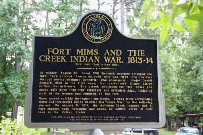
| | Here in Creek Indian War 1813-14 took place most brutal massacre in American history.
Indians took fort with heavy loss, then killed all but about 36 of some 550 in the fort.
Creeks had been armed by British at Pensacola in this phase . . . — — Map (db m86293) HM |
May. 3, 2024