3 entries match your criteria.
Related Historical Markers
By Mike Stroud, January 19, 2010
St. Mark's Episcopal Church Marker, reverse side
SHOWN IN SOURCE-SPECIFIED ORDER
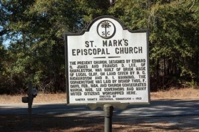
| | (Front text) By Act of Assembly St. Mark's Parish was established in 1757. The first Church stood at Halfway Swamp. Others were built near Williamsburg-Sumter Line, near Rimini, and near this site. These four churches were abandoned or . . . — — Map (db m27134) HM |
| | During the American Revolution, December 1780, over 750 recently arrived British fusiliers were marching from Nelson’s Ferry on the Santee River. Major McLeroth’s British troops from Moncks Corner joined them as an escort to Camden. General Marion’s . . . — — Map (db m24370) HM |
| | In December 1781, Maj. Robert McLeroth and the 64th Regiment were conducting newly-arrived British army recruits of the Royal Fusiliers from Charleston to the High Hills of Santee. Learning of McLeroth’s movement, Col. Francis Marion led some 700 . . . — — Map (db m227715) HM |
May. 7, 2024