6 entries match your criteria.
Related Historical Markers
By Cosmos Mariner, May 27, 2013
Battle Of Talladega Marker
SHOWN IN SOURCE-SPECIFIED ORDER
| On East Battle Street at Court Street North, on the right when traveling west on East Battle Street. |
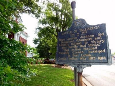
| | Here Andrew Jackson led Tennessee Volunteers and friendly Indians to victory over hostile “Red Sticks.”
This action rescued friendly Creeks besieged in Fort Leslie.
Creek Indian War 1813 - 1814. — — Map (db m28205) HM |
| On State Highway 22 East at Church Street, on the right when traveling north on State Highway 22 East. |
| | Jackson fortified position here during Creek Indian War (1813-1814). Although repeated attacks by the Red Sticks were repulsed, Jackson withdrew with the Indians pursuing. — — Map (db m45736) HM |
| On Fort Mims Road north of Boatyard Road (County Route 80), on the right. |
| | Front:
In 1813, people on the United State’s southwestern frontier were fearful. The Redstick faction of the Creek Indian Nation opposed growing American influence in the area and had voted for war. However, Creeks living in the Tensaw . . . — — Map (db m116678) HM |
| On Our Childrens Highway (State Highway 63) at Walker Ferry Road, on the right when traveling south on Our Childrens Highway. Reported missing. |
| | Indian farmer - merchant chose to resist whites' advance on Indians' lands. In Creek War he led Creeks at Battle of Horseshoe Bend. His warriors were beaten by Jackson's superior force but Menawa escaped. — — Map (db m66680) HM |
| On Alabama Route 21 at milepost 19 at H-Kyle Road, on the right when traveling north on State Route 21. |
| | Little River was the home of Creek Chief William Weatherford, also known as War Chief Red Eagle. This was the area of much discussion and debate, bringing the Creeks into the War of 1812 and the Creek Civil War of 1813-1814. These events weighed . . . — — Map (db m86271) HM |
| On Shady Grove Road (Alabama Route 9) at Alabama Route 63, on the right when traveling north on Shady Grove Road. |
| | Hostile Creeks attacked Andrew Jackson, withdrawing to Ft. Strother, Jan. 24, 1814. His troops broke through lines, kept on to Ft. Strother. But Creeks boasted that they defeated 'Capt. Jack', drove him to the Coosa. — — Map (db m95076) HM |
Apr. 29, 2024