On Laurens Street SW south of Richland Avenue W, on the right when traveling south.
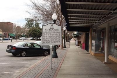
On January 27, 1953, an explosion caused
by a natural gas leak killed ten people
and destroyed five buildings on the
northern half of this block. The five
buildings destroyed were Platt's Drug Store,
the Jones Electric Company (the site . . . — — Map (db m28716) HM
On Laurens Street SW near The Alley, on the right when traveling north.
Aiken, chartered in 1835 and the county seat of Aiken County since its creation in 1871, was an early stop on the railroad line from Charleston to Hamburg. It was named for William Aiken (1779–1831), the first president of the S.C. Canal and . . . — — Map (db m9640) HM
On Williamsburg Street near Richland Street SE (U.S. 78), in the median.
The Aiken County Farmers’ Market, founded in 1951, was originally an open air market sponsored by the Edisto Grange. This building, which opened on May 21, 1954, was designed by Woodrow Jackson and built by the Aiken County chain gang. Farmers . . . — — Map (db m28630) HM
On Richland Avenue W (U.S. 1) near Morgan Street, on the right when traveling west.
Aiken Hospital
The first public hospital in Aiken, at the corner of Richland Ave. and Vaucluse Rd., was built in 1917 for the Aiken Hospital and Relief Society, with donations from members of the “Aiken Winter Colony.” The City of . . . — — Map (db m54518) HM
Near near Robert M. Bell Parkway (State Highway 19 /118).
(Front text)
This plantation house, first known as “Edgewood,” is an excellent example of Federal-era architecture. Originally near Edgefield, it was built in 1828 for Francis W. Pickens (1807-1869), state representative and . . . — — Map (db m43154) HM
On Kershaw Street NW, on the right when traveling north.
This school was founded by the Freedmen's Bureau shortly after the Civil War to educate freedmen, women, and children. In 1868 Martha Schofield, a Quaker from Pennsylvania, came to Aiken and began her long career as superintendent. The school soon . . . — — Map (db m28821) HM
On Laurens Street North West (State Highway 19) north of Jones Avenue, on the right when traveling north.
German prisoners of war were held in a camp on this site from November 1943 to May 1946. This camp, one of 21 in S.C., was at first a sub-camp of the POW camp at Camp Gordon (now Fort Gordon), in Augusta, Ga. It was later a sub-camp of Fort . . . — — Map (db m36396) HM
On Johnston Highway (State Highway 191) 0.2 miles north of State Highway 19, on the right when traveling south.
This house was for many years the home of Marie Cromer Seigler (1882-1964), educator and national pioneer in agricultural instruction. In 1910, as teacher and principal of Talatha School, she founded a Girls' Tomato Club, the first of many such . . . — — Map (db m28714) HM
On Marshall Street near Canal Street, on the right when traveling east.
This mill, the largest textile mill in antebellum S.C., was chartered in 1845 and opened in 1847. It was founded by William Gregg (1800–1867), a Virginia native and advocate of industrial development who chose this site for its proximity . . . — — Map (db m9763) HM
On Charleston/Augusta Road (U.S. 78) at Old Tory Trail, on the right when traveling east on Charleston/Augusta Road.
Pascalis Plantation
Elizabeth Pascalis purchased these 790 acres in 1835, settled here with her son Cyril Ouviere, and brought the orphaned children of her daughter, here, to live. Cyril, a civil engineer, was a resident engineer . . . — — Map (db m9797) HM