33 entries match your criteria.
Mississippi Freedom Trail Historical Markers
By Cajun Scrambler, June 23, 2023
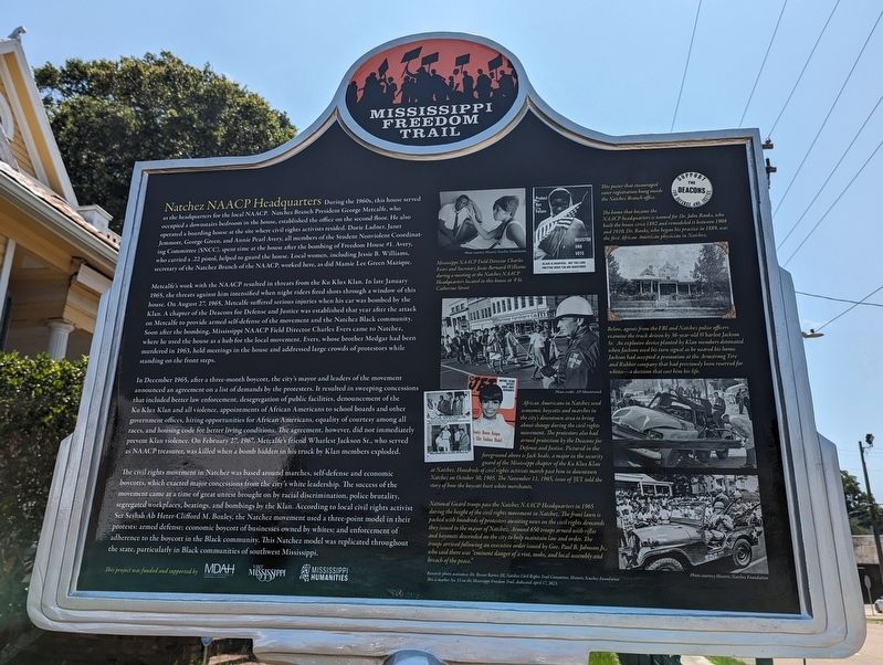
Natchez NAACP Headquarters Marker
| 1 ► Mississippi, Adams County, Natchez — 33 — Natchez NAACP Headquarters — Mississippi Freedom Trail — |
| On Saint Catherine Street near Abbott Street, on the right when traveling west. | |||
| 2 ► Mississippi, Bolivar County, Cleveland — 9 — Amzie Moore — Mississippi Freedom Trail — |
| On South Chrisman Avenue at Ruby Street, on the right when traveling south on South Chrisman Avenue. | |||
| 3 ► Mississippi, Bolivar County, Mound Bayou — 8 — T.R.M. Howard — Mississippi Freedom Trail — |
| On Edwards Avenue at Roosevelt Street, on the right when traveling south on Edwards Avenue. | |||
| 4 ► Mississippi, Coahoma County, Clarksdale — 16 — Aaron Henry — Mississippi Freedom Trail — |
| On Martin Luther King Boulevard at Ashton Alley, on the right when traveling west on Martin Luther King Boulevard. | |||
| 5 ► Mississippi, DeSoto County, Hernando — 24 — March Against Fear — Mississippi Freedom Trail — |
| On U.S. 51 at Vinson Road, on the right when traveling south on U.S. 51. | |||
| 6 ► Mississippi, Forrest County, Hattiesburg — 27 — Clyde Kennard — Mississippi Freedom Trail — |
| Near East Memorial drive south of Smalling Drive, on the right when traveling north. | |||
| 7 ► Mississippi, Harrison County, Biloxi — 29 — Biloxi Beach Wade-In — Mississippi Freedom Trail — |
| On Beach Boulevard (U.S. 90) at Porter Avenue, on the right when traveling east on Beach Boulevard. | |||
| 8 ► Mississippi, Harrison County, Pass Christian — 35 — Lawrence Guyot — Mississippi Freedom Trail — |
| On Handy Lane at Davis Avenue, on the right when traveling west on Handy Lane. | |||
| 9 ► Mississippi, Hinds County, Clinton — 32 — The Clinton Massacre — Mississippi Freedom Trail — |
| On West Northside Drive, 0.2 miles west of Vernon Road, on the left when traveling west. | |||
| 10 ► Mississippi, Hinds County, Jackson — 28 — Bombings in Jewish Community — Mississippi Freedom Trail — |
| On Old Canton Road south of River Thames Road, on the right when traveling south. | |||
| 11 ► Mississippi, Hinds County, Jackson — 25 — Jackson Municipal Library Sit-In — Mississippi Freedom Trail — |
| On North State Street south of Mississippi Street, on the left when traveling north. | |||
| 12 ► Mississippi, Hinds County, Jackson — 2 — Medgar Evers Home — Mississippi Freedom Trail — |
| On Margaret W Alexander Drive east of Missouri Street, on the left when traveling east. | |||
| 13 ► Mississippi, Hinds County, Jackson — 30 — WLBT-TV — Mississippi Freedom Trail — |
| On South Jefferson Street south of Morris Street, on the right when traveling south. | |||
| 14 ► Mississippi, Hinds County, Jackson — 12 — Woolworth's Sit-in — Mississippi Freedom Trail — |
| On East Capitol Street east of North Farish Street, on the right when traveling west. | |||
| 15 ► Mississippi, Hinds County, Jackson, Belhaven — 19 — Capitol Rally — Mississippi Freedom Trail — |
| On High Street, 0.1 miles east of North West Street, on the right when traveling east. | |||
| 16 ► Mississippi, Hinds County, Jackson, Farish Street Historic District — 5 — Greyhound Bus Station — Mississippi Freedom Trail — |
| On North Lamar Street south of East Griffith Street, on the right when traveling south. | |||
| 17 ► Mississippi, Hinds County, Jackson, Washington Addition — 23 — COFO Central Offices — Mississippi Freedom Trail — |
| On John R. Lynch Street at Short Hickory Street, in the median on John R. Lynch Street. | |||
| 18 ► Mississippi, Hinds County, Jackson, Washington Addition — 6 — Jackson State Tragedy — Mississippi Freedom Trail — |
| Near Gibbs-Green Plaza, 0.1 miles west of Dalton Street, on the right when traveling west. | |||
| 19 ► Mississippi, Hinds County, Jackson, Washington Addition — 6a — Jackson State Tragedy — Mississippi Freedom Trail — |
| On John R. Lynch Street west of South Prentiss Street, on the right when traveling east. | |||
| 20 ► Mississippi, Hinds County, Tougaloo — 13 — Tougaloo College — Mississippi Freedom Trail — |
| Near Berkshire Drive north of Tougaloo Boulevard. | |||
| 21 ► Mississippi, Humphreys County, Belzoni — 11 — The Reverend George Lee — Mississippi Freedom Trail — |
| On Church Street at First Street (Mississippi Highway 7), on the left when traveling north on Church Street. | |||
| 22 ► Mississippi, Issaquena County, Mayersville — 22 — Unita Blackwell — Mississippi Freedom Trail — |
| On Court Street east of Court Street, on the right when traveling east. | |||
| 23 ► Mississippi, Lafayette County, University — 7 — University of Mississippi — Mississippi Freedom Trail — |
| Near Galtney-Lott Plaza west of University Circle. | |||
| 24 ► Mississippi, Leflore County, Greenwood — 10 — "Black Power" Speech — Mississippi Freedom Trail — |
| On Broad Street at Avenue M, on the right when traveling west on Broad Street. | |||
| 25 ► Mississippi, Leflore County, Itta Bena — 33 — Hopewell Missionary Baptist Church — Mississippi Freedom Trail — |
| On Douglas Street east of College Street, on the right when traveling east. | |||
| 26 ► Mississippi, Leflore County, Money — 1 — Bryant's Grocery — Mississippi Freedom Trail — |
| On Money Road (County Road 518) at County Road 24, on the left when traveling north on Money Road. | |||
| 27 ► Mississippi, Madison County, Canton — 21 — Madison County Movement — Mississippi Freedom Trail — |
| On North Liberty Street (U.S. 51) at West Peace Street (State Highway 22), on the left when traveling north on North Liberty Street. | |||
| 28 ► Mississippi, Marshall County, Holly Springs — 18 — Rust College — Mississippi Freedom Trail — |
| On Rust Avenue east of North Memphis Street (State Route 7), on the right when traveling east. | |||
| 29 ► Mississippi, Pike County, McComb — 15 — C.C. Bryant — Mississippi Freedom Trail — |
| On C.C. Bryant Drive near Adams Avenue. | |||
| 30 ► Mississippi, Quitman County, Marks — 20 — Marks Mule Train and Poor Peoples Campaign — Mississippi Freedom Trail — |
| On Roger Road at Martin L King Jr Drive (State Route 3), on the right when traveling east on Roger Road. | |||
| 31 ► Mississippi, Sunflower County, Ruleville — 14 — Fannie Lou Hamer — Mississippi Freedom Trail — |
| On Byron Street east of Bishop Smith Carter Avenue, on the left when traveling east. | |||
| 32 ► Mississippi, Sunflower County, Ruleville — 26 — William Chapel — Mississippi Freedom Trail — |
| On O B Avenue at Elisha and Everette Langdon Street, on the right when traveling north on O B Avenue. | |||
| 33 ► Mississippi, Tippah County, Blue Mountain — 17 — Carpenters for Christmas — Mississippi Freedom Trail |
| On County Road 700, 0.4 miles north of County Road 725, on the left when traveling north. Reported unreadable. | |||