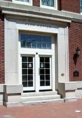
On 1st Street at Mosley Street, on the left when traveling east on 1st Street.
Built as Wholesale Hardware Building
at a cost of $250,000
for Morton-Simmons Hardware Co.
featuring Keen Kutter Tools
and Equipment
Architect: Mauran, Russell and Garden,
St. Louis, Missouri
Builder: Wurster Construction Company, . . . — — Map (db m56450) HM
On 1st Street at Mead Street, on the left when traveling east on 1st Street.
Built as free-standing wholesale
grocery warehouse for $70,000
Architect: Fred G. McCune,
Wichita, Kansas
Renovated: 1998 as Office
Historic & Current Address:
800 East First — — Map (db m56432) HM
On Rock Island Street near 1st Street, on the left when traveling north.
Built For The Grant-Billingsley
Fruit Company
(First of 4 Buildings)
Historic Address: 133 N. Rock Island
Current Address: 131 N. Rock Island — — Map (db m56486) HM
On 12th Street at SW Taylor Street, on the right when traveling west on 12th Street.
This property has been
placed on the
National Register
of Historic Places
by the United States
Department of the Interior
Historic Topeka Inc.
Preservation Award
1994 — — Map (db m63884) HM
On SW 10th Avenue at SW Jackson Street, on the right when traveling west on SW 10th Avenue.
This tablet was erected by
the State of Kansas
to the memory of
Charles Henry Chandler
the designer of this building
State Architect
MCMIX - MCMXVIII — — Map (db m61427) HM WM
On SW 10th Avenue near SW Topeka Boulevard, on the right when traveling west.
has been placed on the
National Register
of Historic Places
by the United States
Department of the Interior
November 1, 2006
and on the
Register of
Historic Kansas Places
by the State of Kansas
August 26, 2006 . . . — — Map (db m50789) HM
Under construction for thirty-seven years, the Capitol building was completed in 1903 at a cost of $3,200,588.92. It was considered among the most architecturally handsome buildings in the nation.
At a height of 304 feet, the Kansas Capitol is . . . — — Map (db m46993) HM
This life-sized sculpture depicted the 22-foot Kansas Capitol dome sculpture "Ad Astra" is a gift to the people of Kansas from the Honorable Bill Graves, forty-third governor of Kansas.
It is presented as a proud symbol of our state's heritage, . . . — — Map (db m46998) HM
Anthony Ward constructed this home between 1870 and 1874. Two sides are built of handsome brick and two of native limestone. The house was remodeled between 1900 and 1905 after it was occupied by the Ward's daughter, Jennie Ward Meade and her . . . — — Map (db m65037) HM
Near East Highland Avenue just east of South Chestnut Street, on the right when traveling east.
The Johnson Branch Santa Fe Depot was built in 1923 and sold at auction 60 years later in 1983. It was purchased by Alfred Ramsay and donated to the Stanton County Historical Society as a museum. — — Map (db m212927) HM
On South Main Street (U.S. 81) at East 1st Avenue, on the left when traveling north on South Main Street.
Caldwell "The Border Queen"
Founded 1871, incorporated 1879 by a town company of investors from Wichita and named for U. S. Sen. Alexander Caldwell. The original townsite was north of Ave. F, the Kansas state line prior to 1876. . . . — — Map (db m96545) HM
On South Main Street (U.S. 81) at East 1st Avenue, on the left when traveling south on South Main Street.
This corner was occupied by the Exchange Saloon, the site of many shooting incidents between cowpokes and outlaws during the 1870s and 1880s. The saloon was destroyed by fire in 1898. The first floor of this building was built in 1902 with materials . . . — — Map (db m96542) HM
On South Main Street (U.S. 81) at West 2nd Avenue, on the right when traveling south on South Main Street.
By 1884 the growing city of Caldwell was interested in promoting the finer cultural aspects of life and plans were made to construct a new Grand Opera House. During that year an opulent three story brick structure was erected on this site. It was . . . — — Map (db m96546) HM
On South Main Street (U.S. 81) north of East First Avenue, on the right when traveling north.
The first building erected at Caldwell was, appropriately enough, a saloon. Constructed of thick logs in 1869 by Curley Marshall, it was located about a mile southeast of this marker on the north bank of Bluff Creek. It was open for business in time . . . — — Map (db m96531) HM
On South Main Street (U.S. 81) at West 1st Avenue, on the right when traveling south on South Main Street.
The Leland Hotel stood here from 1880 to 1970 when a fire swept through the historic structure. It was built of brick, 3 stories high, 46 guest rooms each with its own running water, a billiard hall, barber shop, bridal chamber, barroom, dining hall . . . — — Map (db m96541) HM
On South Main Street (U.S. 81) at West 1st Avenue, on the right when traveling south on South Main Street.
The Stock Exchange Bank is the oldest business in Caldwell and occupies one of the oldest surviving buildings in town. It received a State Charter on November 12, 1881 and opened for business the following December 24th. The stone building erected . . . — — Map (db m96544) HM
On Missouri Avenue (State Highway 99) at 4th Street, on the left when traveling south on Missouri Avenue.
This beautiful native stone building was originally known as the Brandt Hotel. For many years this hotel was host to many salesmen, politicians, and travelers visiting Alma. — — Map (db m64850) HM
On Missouri Avenue (State Highway 99) at 3rd Street, on the left when traveling south on Missouri Avenue.
This fine stone building was at one time a bawdy saloon of the early days and then served as a formal, dignified bank. A large arched wine cellar beneath it is still preserved in its original state. — — Map (db m64861) HM
On Missouri Avenue (State Highway 99) at 4th Street, on the left when traveling south on Missouri Avenue.
This beautiful and stately native stone building was once one of the finest buildings in town. Being named after the two Irish brothers who built it, it is referred to as the Limerick Building. — — Map (db m64849) HM
On Missouri Avenue (State Highway 99) at 3rd Street, on the left when traveling south on Missouri Avenue.
This stone building was built by Mr. Conrad Mueller and operated as a saloon until Prohibition. He then started a hardware business. — — Map (db m64859) HM
On Missouri Avenue south of 3rd Street, on the left when traveling south.
Originally known as the Palenske Building, this beautiful two story stone building originally housed a bookstore. It was also a bank at one time. The detailed scrollwork around the doorway adds a unique touch to this building. — — Map (db m64877) HM
On Missouri Avenue (State Highway 99) south of 4th Street, on the right when traveling south.
Both the Wabaunsee County Bank and C.O. Kinne and R.J. Kerans General Merchandise store occupied this ornate native stone building at one time. — — Map (db m64858) HM
On North 4th Street at East J Street on North 4th Street.
Municipal Auditorium
& City Hall
Has Been Listed in the
National Register
of Historic Places
By the United States
Department of the Interior
WPA Project
1939-1942 — — Map (db m199544) HM
On Main Street (U.S. 75) at 6th Street, on the left when traveling west on Main Street.
This property has been
placed on the
National Register
of Historic Places
by the United States
Department of the Interior
Circa 1896 — — Map (db m57601) HM
136 entries matched your criteria. Entries 101 through 136 are listed above. ⊲ Previous 100