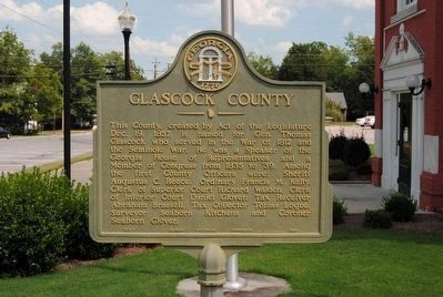
On East Main Street at Palmer Street, on the right when traveling east on East Main Street.
This County, created by Act of the Legislature Dec. 19, 1857, is named for Gen. Thomas Glascock who served in the War of 1812 and the Seminole War. He was a Speaker of the Georgia House of Representatives and a Member of Congress from 1835 to . . . — — Map (db m55549) HM
On Main Street (County Route 113) east of Warren Street, on the left when traveling east.
A great American hero
and the namesake of Mitchell, GA.
Graduated Lynchburg Military College
Joined the Confederate Army as a Lt. on Apr. 22, 1861, at age 16, Army of Northern VA; Langhorne’s Corp.; Pickett’s Div.;
Longstreet’s Brigade; . . . — — Map (db m61364) HM
On Court Square at Norwood Street, on the right when traveling west on Court Square.
[Center Panel]:
The Formation of and Changes in the Warren County Boundary Line
Warren County was created by an Act of the Legislature on December 19, 1793. Parts of the counties of Richmond, Columbia, and Wilkes were taken to form . . . — — Map (db m90436) HM
On East Main Street (State Highway 102), on the right when traveling east.
1776 - 1976
[Crossed U.S. and Georgia Flags]
By the Citizens & Friends
of Glascock County in
Commemoration of Our
Nation's Two Hundredth
Birthday — — Map (db m90543) HM
Thin black lines indicate changes in relevance. Between each pair of lines entries are ordered geographically but all have the same relevance.
* Inflectional forms of words are their plurals, singulars, and possessives as well as gramatical tenses and similar variations.