On Pea Ridge Highway (State Highway 44-13) at Mt. Joy Church Road (State Highway 44-260), on the left when traveling east on Pea Ridge Highway.
[Front]:
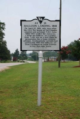
On April 20, 1861, only days after the Civil War began at Fort Sumter, scientist and aeronaut T.S.C. Lowe (1832-1913) landed the Enterprise, a large gas balloon, on a nearby farm. Lowe was on a test flight in preparation . . . — — Map (db m23919) HM
On North Mountain Street at Hames Street, in the median on North Mountain Street.
[Front Side]:
This Greek Revival house was built ca. 1857 for Benjamin Dudley Culp (1821-1885) and his wife Cornelia Meng Culp (1830-1888). Culp, a Union merchant, owned stores on Main Street with partners J.T. Hill and H.L. Goss from . . . — — Map (db m13542) HM
On Cross Keys Highway (State Highway 49) 0.5 miles west of Riley Road, on the right when traveling west.
Fair Forest Plantation
Fair Forest, named for nearby Fair Forest Creek, was the plantation of Col. Thomas Fletchall (d.1789), prominent militia officer before the Revolution and Loyalist during it. Captured in 1775 and briefly jailed, Fletchall . . . — — Map (db m13394) HM
On North Pinckney Street, on the right when traveling north.
[Front]:
This cemetery, the oldest in Union, was established ca. 1817 and sometimes called the "village cemetery." In 1818 a Presbyterian "union" church used by other denominations as well moved here from a 1783 site about 2 mi. E. . . . — — Map (db m81836) HM
On West Main Street (State Highway 49) just east of South Enterprise Street, on the right when traveling west.
In 1871, one of the worst waves of white supremacist violence in S.C. history unfolded in Union County. During two raids in Jan. and Feb. of that year, twelve Black men were forcibly taken from this jail by the Ku Klux Klan while awaiting trial. . . . — — Map (db m196465) HM