Fort Pierce in St. Lucie County, Florida — The American South (South Atlantic)
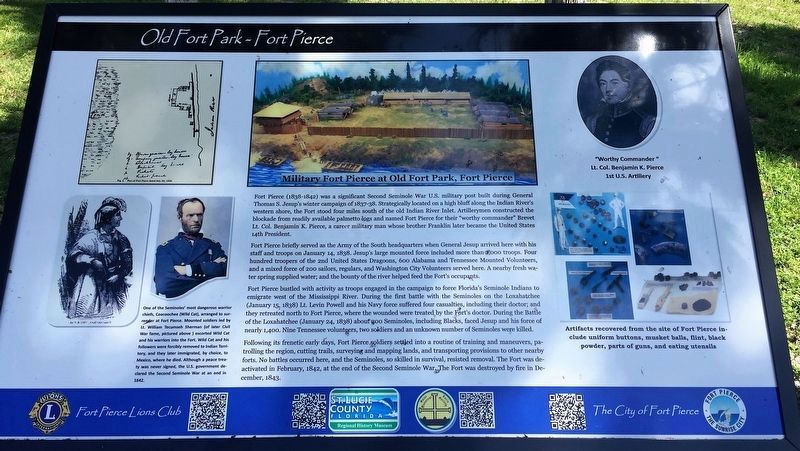
Military Fort Pierce at Old Fort Park, Fort Pierce
Old Fort Park - Fort Pierce
Inscription.
Fort Pierce (1838-1842) was a significant Second Seminole War U.S. military post built during General Thomas S. Jesup’s winter campaign of 1837-38. Strategically located on a high bluff along the Indian River’s western shore, the Fort stood four miles south of the old Indian River Inlet. Artillerymen constructed the blockade from readily available palmetto logs and named Fort Pierce for their "worthy commander" Brevet Lt. Col. Benjamin K. Pierce, a career military man whose brother Franklin later became the United States 14th President.
Fort Pierce briefly served as the Army of the South headquarters when General Jesup arrived here with his staff and troops on January 14, 1838. Jesup's large mounted force included more than 1,000 troops. Four hundred troopers of the 2nd United States Dragoons, 600 Alabama and Tennessee Mounted Volunteers, and a mixed force of 200 sailors, regulars, and Washington City Volunteers served here. A nearby fresh water spring supplied water; and the bounty of the river helped feed the Fort's occupants.
Fort Pierce bustled with activity as troops engaged in the campaign to force Florida's Seminole Indians to emigrate west of the Mississippi River. During the first battle with the Seminoles on the Loxahatchee (January 15, 1838) Lt. Levin Powell and his Navy force suffered four casualties, including their doctor; and they retreated north to Fort Pierce, where the wounded were treated by the Fort's doctor. During the Battle of the Loxahatchee (January 24, 1838) about 200 Seminoles, including Blacks, faced Jesup and his force of nearly 1,400. Nine Tennessee volunteers, two soldiers and an unknown number of Seminoles were killed.
Following its frenetic early days, Fort Pierce soldiers settled into a routine of training and maneuvers, patrolling the region, cutting trails, surveying and mapping lands, and transporting provisions to other nearby forts. No battles occurred here, and the Seminoles, so skilled in survival, resisted removal. The Fort was deactivated in February, 1842, at the end of the Second Seminole War. The Fort was destroyed by fire in December, 1843.
Captions:
Military Fort Pierce at Old Fort Park, Fort Pierce
One of the Seminoles' most dangerous warrior chiefs, Coacoochee (Wild Cat), arranged to surrender at Fort Pierce. Mounted soldiers led by Lt. William Tecumseh Sherman (of later Civil War fame, pictured above) escorted Wild Cat and his warriors into the Fort. Wild Cat and his followers were forcibly removed to Indian Territory, and they later immigrated, by choice, to Mexico, where he died. Although a peace treaty was never signed, The U.S. government declared the Second Seminole War at an end in 1842.
"Worthy
Commander" Lt. Col. Benjamin K. Pierce 1st U.S. Artillery
Artifacts recovered from the site of Fort Pierce include uniform buttons, musket balls, flint, black powder, parts of guns, and eating utensils.
Erected 2016 by Fort Pierce Lions Club, Saint Lucie Regional History Museum, Saint Lucie Historical Society, City of Fort Pierce.
Topics. This historical marker is listed in these topic lists: Forts and Castles • Native Americans • Wars, US Indian. A significant historical year for this entry is 1838.
Location. 27° 26.236′ N, 80° 19.221′ W. Marker is in Fort Pierce, Florida, in St. Lucie County. Marker can be reached from South Indian River Drive (County Road 707) 0.3 miles south of Florida Avenue, on the right when traveling south. Marker is in Old Fort Park. Touch for map. Marker is at or near this postal address: 901 South Indian River Drive, Fort Pierce FL 34950, United States of America. Touch for directions.
Other nearby markers. At least 8 other markers are within 2 miles of this marker, measured as the crow flies. Traces of an Early Indian Village (within shouting distance of this marker); Old Fort Park (within shouting distance of this marker); Fort Pierce (within shouting distance of this marker); St. Lucie County (approx. 0.6 miles away); A.E. “Beanie” Backus Studio (approx. one mile away); A.E. “Bean” Backus (approx. one mile away); St. Lucie County Veterans Memorial (approx. 1.2 miles away); The United States Submarine Service Memorial (approx. 1.2 miles away). Touch for a list and map of all markers in Fort Pierce.
Credits. This page was last revised on August 3, 2019. It was originally submitted on August 17, 2017, by Jay Kravetz of West Palm Beach, Florida. This page has been viewed 907 times since then and 70 times this year. Photos: 1, 2. submitted on August 17, 2017, by Jay Kravetz of West Palm Beach, Florida. • Bernard Fisher was the editor who published this page.

