Atchafalaya Floodway
Indian Bayou
— Atchafalaya Water Heritage Trail —
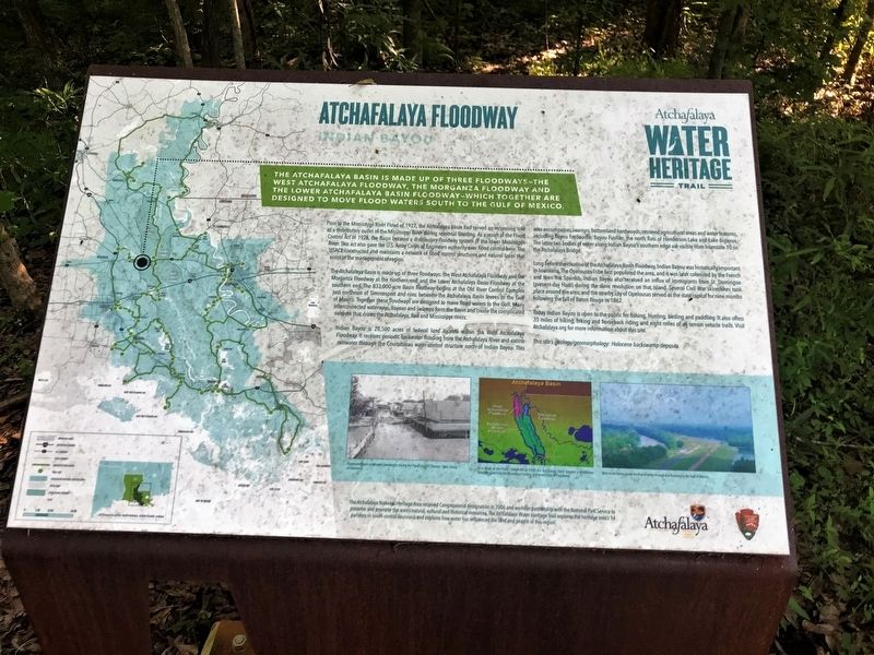
The Atchafalaya Basin is made up of three floodways - The West Atchafalaya Floodway, The Morganza Floodway and the Lower Atchafalaya Basin Floodway - which together are designed to move floodwaters south to the Gulf of Mexico.
Prior to the Mississippi River Flood of 1927, the Atchafalaya Basin had served an increasing role as a distributary outlet of the Mississippi River during seasonal flooding. As a result of the Flood Control Act of 1928, the Basin became a distributary floodway system of the lower Mississippi River. This act also gave the U.S. Army Corps of Engineers authority over flood control here. The USACE constructed and maintains a network of flood control structures and natural areas that assist in the management of region. The Atchafalaya Basin is made up of three floodways: the West Atchafalaya Floodway and the Morganza Floodway at the northern end and the Lower Atchafalaya Basin Floodway at the southern end. The 833,000-acre Basin floodway begins at the Old River Control Complex just northeast of Simmesport and runs between the Atchafalaya Basin levees to the Gulf of Mexico. Together these floodways are designed to move flood waters to the Gulf. Many interconnected waterways, bayous and swamps form the Basin and create the complicated network that drains the Atchafalaya, Red and Mississippi rivers.
Indian
Bayou is 28,500 acres of federal land located within the West Atchafalaya Floodway. It receives periodic backwater flooding from the Atchafalaya River and excess rainwater through the Courtableau water-control structure north of Indian Bayou. This area encompasses swamps, bottomland hardwoods, restored agricultural areas and water features, including Bayou Fordouche, Bayou Fusilier, the north flats of Henderson Lake and Lake Bigeaux. The latter two bodies of water along Indian Bayou’s southern edge are visible from Interstate 10 on the Atchafalaya Bridge.Long before the creation of the Atchafalaya Basin Floodway, Indian Bayou was historically important in Louisiana. The Opelousas Tribe first populated the area, and it was later colonized by the French and then the Spanish. Indian Bayou also received an influx of immigrants from St. Domingue (present-day Haiti) during the slave revolution on that island. Several Civil War skirmishes took place around the area, and the nearby city of Opelousas served as the state capital for nine months following the fall of Baton Rouge in 1862.
Today Indian Bayou is open to the public for fishing, hunting, birding and paddling. It also offers 35 miles of hiking, biking and horseback riding and eight miles of all-terrain vehicle trails.
Visit Atchafalaya.org for more information about this site.
This site’s geology/geomorphology: Holocene backswamp deposits
Erected by State of Louisiana and National Park Service.
Topics and series. This historical marker is listed in these topic lists: Environment • Waterways & Vessels. In addition, it is included in the Atchafalaya Water Heritage Trail series list.
Location. 30° 24.404′ N, 91° 42.622′ W. Marker is in Krotz Springs, Louisiana, in St. Landry Parish. Marker can be reached from West Atchafalaya Floodway Road (Parish Highway 3-95) 6 miles north of Interstate 10. Located at the Indian Bayou WMA. Touch for map. Marker is in this post office area: Krotz Springs LA 70750, United States of America. Touch for directions.
Other nearby markers. At least 8 other markers are within 11 miles of this marker, measured as the crow flies. Bottomland Hardwoods (approx. 2.6 miles away); Big Alabama Bayou (approx. 2.6 miles away); Atchafalaya River (approx. 4.6 miles away); Louisiana Airborne Memorial Bridge (approx. 4.6 miles away); a different marker also named Atchafalaya Floodway (approx. 7.8 miles away); a different marker also named Atchafalaya River (approx. 8.9 miles away); Louis Hebert (approx. 9.8 miles away); Stephanie-Martin Duralde House (approx. 10.6 miles away). Touch for a list and map of all markers in Krotz Springs.
Credits. This page was last revised on March 18, 2022. It was originally submitted on May 7, 2018, by Cajun Scrambler of Assumption, Louisiana. This page has been viewed 342 times since then and 33 times this year. Photos: 1, 2. submitted on May 7, 2018, by Cajun Scrambler of Assumption, Louisiana.

