Mérida, Yucatán, Mexico — The Southeast (Yucatan Peninsula)
The San Juan Arch
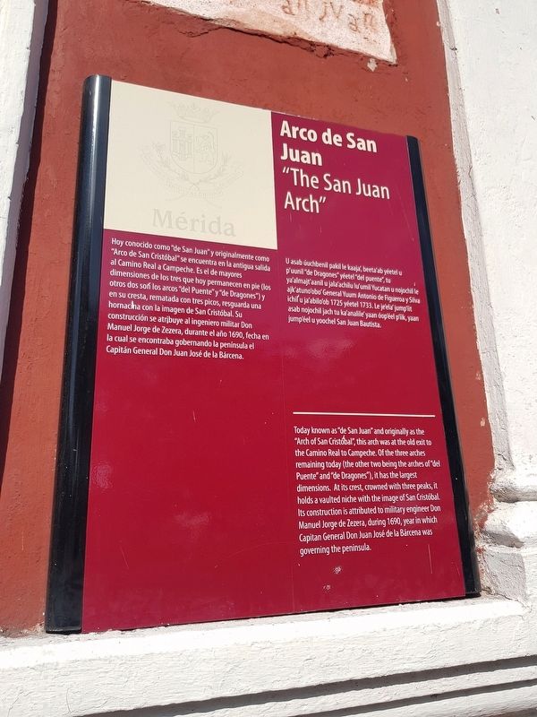
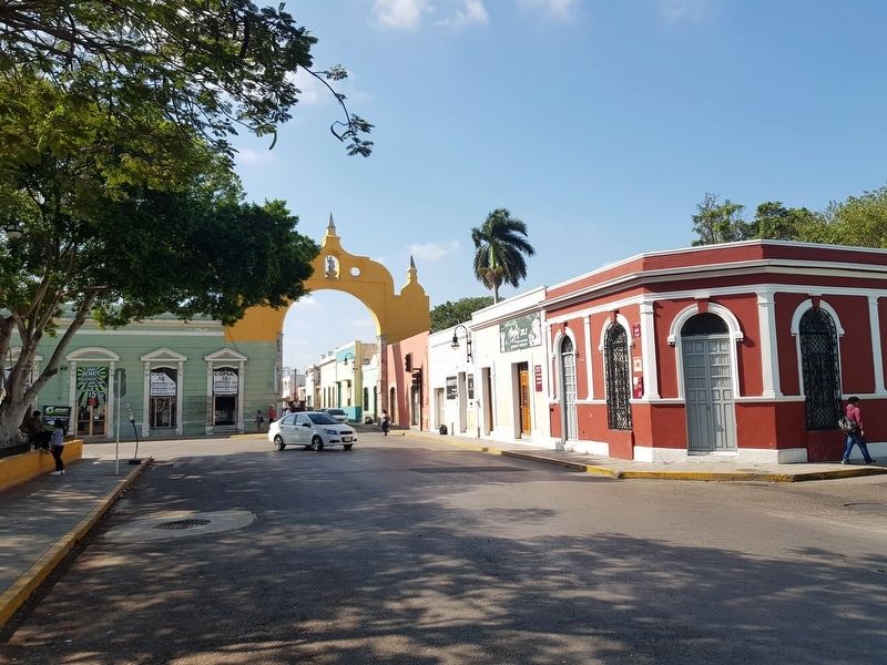
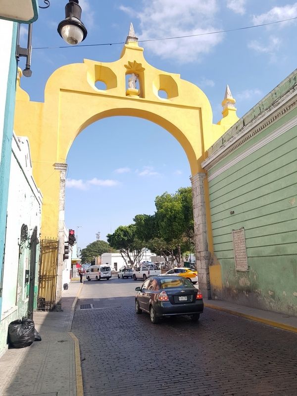
Hoy conocido como “de San Juan” y originalmente como “Arco de San Cristóbal” se encuentra en la antigua salida al Camino Real a Campeche. Es el de mayores dimensiones de los tres que hoy permanecen en pie (los otros dos son los arcos "del Puente" y "de Dragones") y en su cresta, rematada con tres picos, resguarda una hornacina con la imagen de San Cristóbal. Su construcción se atribuye al ingeniero militar Don Manuel Jorge de Zezera, durante el año 1690, fecha en la cual se encontraba gobernando la península el Capitán General Don Juan José de la Bárcena.
Arco de San Juan
U asab úuchbenil pakil le kaaja', beeta'ab yéetel u p'uunil “de Dragones” yéetel “del puente”, tu ya'almajt'aanil u jala'achilu lu'umil Yucatan u nojochil le ajk'atuno'obo' General Yuum Antonio de Figueroa y Silva ichil u ja'abilo'ob 1725 yéetel 1733. Le je'ela' jump'íit asab nojochil jach tu ka'analile' yaan óop'éel p'íik, yaan jump'éel u yoochel San Juan Bautista.
The San Juan Arch
Today known as “de San Juan” and originally as the “Arch of San Cristóbal”, this arch was at the old exit to the Camino Real to Campeche. Of the three arches remaining today (the other two being the arches of “del Puente” and “de Dragones”), it has the largest dimensions. At its crest, crowned with three peaks, it holds a vaulted niche with the image of San Cristóbal. Its construction is attributed to military engineer Don Manuel Jorge de Zezera, during 1690, year in which Capitan General Don Juan José de la Bárcena was governing the peninsula.
Topics. This historical marker is listed in these topic lists: Architecture • Colonial Era • Roads & Vehicles. A significant historical year for this entry is 1690.
Location. 20° 57.755′ N, 89° 37.614′ W. Marker is in Mérida, Yucatán. Marker is at the intersection of Calle 64 and Calle 69, on the left when traveling north on Calle 64. Touch for map. Marker is in this post office area: Mérida YU 97000, Mexico. Touch for directions.
Other nearby markers. At least 8 other markers are within walking distance of this marker. Temple of St. John the Baptist (about 90 meters away, measured in a direct line); Benito Juárez (about 120 meters away); Colegio Montejo Annex (about 150 meters away); Monsignor Norberto Domínguez (about 150 meters away); The House of the Headless Friar (about 210 meters away); Calle 64 (about 240 meters away); Corner of Calle 62 and 67
(about 240 meters away); Consuelo Zavala C. (approx. 0.3 kilometers away). Touch for a list and map of all markers in Mérida.
Photographed By J. Makali Bruton, February 18, 2019
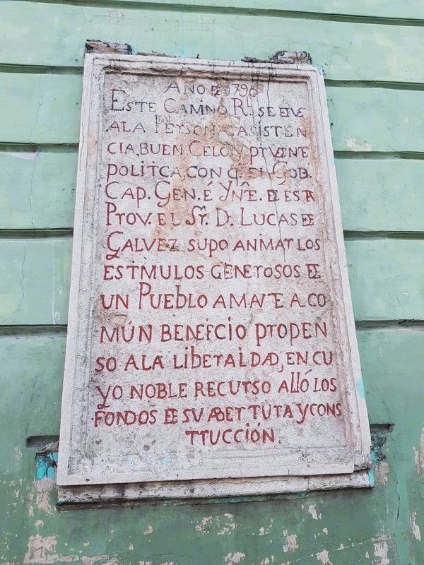
5. An additional nearby marker on the Campeche Royal Road
As the featured marker mentions, the San Juan Arch marks the beginning of the original Royal Road to the port city of Campeche. This nearby marker reads:
Año de 1790
Este Camino Rl. se deve a la Persona Asistencia, buen Celo y prudente política, con q. el Gob. Cap. Gen. e Ynte. de esta Prov. el Sr. D. Lucas de Galvez supo animar los estimulos generosos de un Pueblo amante a común beneficio propenso a la liberalidad, en cuyo noble recurso alló los fondos de su abertura y construcción.
English translation:
In the year 1790, this Royal Road is due to the personal assistance, zealousness and prudent policy with which the Captain General and Intendent of this province, Lucas D. Gálvez, knew how to encourage the generosity of a people that believe in the public good and are prone to liberality, in whose noble resources he was able to encounter the funds to open and construct this road.
Este Camino Rl. se deve a la Persona Asistencia, buen Celo y prudente política, con q. el Gob. Cap. Gen. e Ynte. de esta Prov. el Sr. D. Lucas de Galvez supo animar los estimulos generosos de un Pueblo amante a común beneficio propenso a la liberalidad, en cuyo noble recurso alló los fondos de su abertura y construcción.
In the year 1790, this Royal Road is due to the personal assistance, zealousness and prudent policy with which the Captain General and Intendent of this province, Lucas D. Gálvez, knew how to encourage the generosity of a people that believe in the public good and are prone to liberality, in whose noble resources he was able to encounter the funds to open and construct this road.
Credits. This page was last revised on October 14, 2022. It was originally submitted on March 15, 2019, by J. Makali Bruton of Accra, Ghana. This page has been viewed 184 times since then and 21 times this year. Photos: 1, 2, 3, 4. submitted on March 15, 2019, by J. Makali Bruton of Accra, Ghana. 5. submitted on March 19, 2019, by J. Makali Bruton of Accra, Ghana.
