Longfellow in Minneapolis in Hennepin County, Minnesota — The American Midwest (Upper Plains)
Hiawatha-Minnehaha Corridor
The Museum in the Streets: Minneapolis, Minnesota
— 27th and Lake: Industry and Transportation Infrastructure —
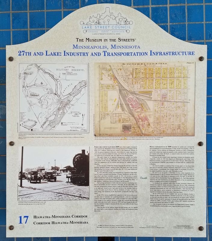
Early area survey maps from 1839 show a trail roughly corresponding to present-day Minnehaha Avenue running between Fort Snelling and the Falls of St. Anthony. Following the creation of the Minnesota Territory in 1849, the general alignment of this trail, which followed a slight ridge that had been used by American Indians for many years before the arrival of the Fort, was improved as a territorial road, also called the Fort Snelling Road.
This path's future as an important transportation corridor was further secured in 1865 when the Minneapolis and Cedar Valley Railroad Company, a forerunner to the Chicago, Milwaukee and St. Paul Railroad, (CM&StT) chose this alignment to lay its railroad track between St. Anthony Falls and Mendota.
As the city grew, it built Fort Avenue alongside the rail line to serve the growing industrial corridor, starting at East 22nd Street and Cedar Avenue and extending Fort Avenue as growth took place. By 1914, maps labeled this diagonal street "Hiawatha Avenue."
By 1933, Hiawatha Avenue was designated as a segment of State Highway 55, which extended from Hastings to Tenney, Minnesota, and the crossing at East Lake Street remained at grade. In 1947, the decision to expand Wold-Chamberlain Field into the Minneapolis-St. Paul Metropolitan Airport added importance to the Hiawatha artery, because it was the most direct—if not complete—connection between downtown and the airport.
The growing movement to build roads that could move increasing numbers of automobiles also drew attention to Hiawatha. By the early 1960s, city and state transportation planners began to plan for Hiawatha Avenue's future as an eight-lane, limited access, high-speed section of the Interstate Highway System. To make way for the new freeway, hundreds of homes were demolished, along with businesses at the intersection of Hiawatha and East Lake Street.
In the 1970s, intense neighborhood opposition to the freeway plan arose, and after years of stalemate and competing proposals, a plan for a four-lane roadway with a light rail transit (LRT) system was approved in the mid-1980s. Final designs for the roadway included a bridge that separated the Hiawatha traffic from Lake Street traffic (opened in 1999), and final designs for the LRT line also included a bridge to separate the line from auto traffic on Lake Street (opened in 2004).
Once the plan for the roadway began moving forward, the City opened the vacant land to redevelopment, building new homes and businesses along the avenue.
El futuro de este sendero como importante corredor de transporte quedó asegurado cuando en 1865 fue elegido por Minneapolis and Cedar Vally Railroad Company, un precursor de la ferroviaria Chicago, Milwaukee and St. Paul Railroad (CM&StP), para instalar su vía férrea entre St. Anthony Falls y Mendota.
Al crecer la ciudad, se construyó Fort Avenue junto a la vía ferroviaria para servir al cresciente corredor industrial, empezando en East 22nd Street y Cedar Aveue, y extendiendo Fort Avenue cuando se necesitaba. Ya en 1914, los mapas designaban a esta calle como "Hiawatha Avenue."
En 1933 ya se designaba a Hiawatha Avenue como segmento de la Carretera Estatal 55, que se extendía desde Hastings hasta Tenney, Minnesota, y el cruce en East Lake Street se mantenía a nivel. En 1947, la decisión de expandir Wold-Chamberlain Field al Minneapolis-St. Paul Metropolitan Airport le dio más importancia a la arteria Hiawatha, al ser la conexión más directa y completa entre el centro y el aeropuerto.
La tendencia de construir calles para circular crecientes números de automóviles también llamó atención a Hiawatha. En los 1960, urbanistas empezaron a planear el futuro de Hiawatha como una sección del sistema de autopistas interestatales de ocho vías, acceso limitado, y alta velocidad. Para hacer lugar para la nueva autopista, se demolieron centenares de casas y negocios en la intersección de Hiawatha y East Lake Street.
En los 1970 surgió en el vecindario una oposición intensa al plan, y después de años de estancamiento y distintas propuestas, en los 80 se aprobó un plan para una pista de cuatro vías con sistema de tren ligero (LRT). Diseños finales incluían un puente separado el tránsito de Hiawatha del de Lake Street (abierto en 1999), y diseños finales para la línea LRT también incluían un puente con la misma idea (abierta en 2004).
Una vez puesto el plan en movimiento, la Ciudad abrió el terreno baldío a la reurbanización, contruyendo casas y negocios nuevos por la avenida.
Erected 2012 by The Museum in the Streets®. (Marker Number 17.)
Topics and series. This historical marker is listed in these topic lists: Native Americans • Railroads & Streetcars • Roads & Vehicles. In addition, it is included in the The Museum in the Streets®: Minneapolis, Minnesota series list. A significant historical year for this entry is 1839.
Location. 44° 56.921′ N, 93° 14.296′ W. Marker is in Minneapolis, Minnesota, in Hennepin County. It is in Longfellow. Marker is at the intersection of E. Lake Street and Hiawatha Avenue (State Highway 55), on the right when traveling west on E. Lake Street. Touch for map. Marker is in this post office area: Minneapolis MN 55406, United States of America. Touch for directions.
Other nearby markers. At least 8 other markers are within walking distance of this marker. 2217 East Lake: Axel's Lunch Room (about 300 feet away, measured in a direct line); Snelling Avenue: African American Community (about 600 feet away); 2108-30 East Lake: Twin City Rapid Transit Lake Street Station and Car Yard (about 600 feet away); Minneapolis-Moline (approx. 0.2 miles away); 2107 East Lake: Porky's Drive-In (approx. 0.2 miles away); 2019 East Lake: Burma Shave (approx. 0.2 miles away); 3010 Minnehaha Avenue South: Fire Station No. 21 (approx. 0.2 miles away); Longfellow School (approx. 0.2 miles away). Touch for a list and map of all markers in Minneapolis.
Credits. This page was last revised on February 12, 2023. It was originally submitted on May 28, 2019, by McGhiever of Minneapolis, Minnesota. This page has been viewed 519 times since then and 88 times this year. Photos: 1, 2. submitted on May 28, 2019, by McGhiever of Minneapolis, Minnesota. • Andrew Ruppenstein was the editor who published this page.

