Saint Croix Falls in Polk County, Wisconsin — The American Midwest (Great Lakes)
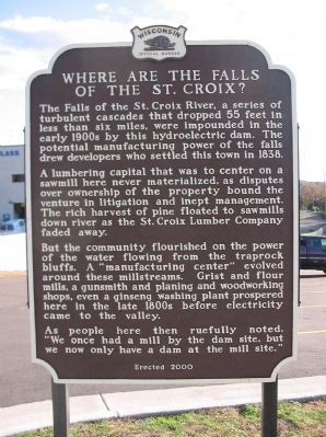
Where Are The Falls of the St. Croix?
A lumbering capital that was to center on a sawmill here never materialized, as disputes over ownership of the property bound the venture in litigation and inept management. The rich harvest of pine floated to sawmills down river as the St. Croix Lumber Company faded away.
But the community flourished on the power of the water flowing from the traprock bluffs. A "manufacturing center" evolved around these millstreams. Grist and flour mills, a gunsmith and planing and woodworking shops, even a ginseng washing plant prospered here in the late 1800s before electricity came to the valley.
As people here then ruefully noted, "We once had a mill by the dam site, but we now only have a dam at the mill site."
Erected 2000 by the Wisconsin Historical Society. (Marker Number 453.)
Topics and series. This historical marker is listed in these topic lists: Industry & Commerce • Man-Made Features • Settlements & Settlers • Waterways & Vessels. In addition, it is included in the Wisconsin Historical Society series list. A significant historical year for this entry is 1838.
Location. 45° 24.745′ N, 92° 38.724′ W. Marker is in Saint Croix Falls, Wisconsin, in Polk County. Marker can be reached from North Washington Street (State Highway 87) north of River Street, on the left when traveling north. Touch for map. Marker is in this post office area: Saint Croix Falls WI 54024, United States of America. Touch for directions.
Other nearby markers. At least 8 other markers are within walking distance of this marker. River Spirit (within shouting distance of this marker); Thompson–Boughton Mill (within shouting distance of this marker); Gaylord Nelson (approx. 0.2 miles away); Where are the Falls? (approx. ¼ mile away); Saint Croix Falls Hydroelectric Project (approx. half a mile away in Minnesota); Chisago Hotel (approx. 0.8 miles away in Minnesota); First Settlement, buildings, steamboat (approx. 0.8 miles away in Minnesota); Town House School (approx. 0.9 miles away in Minnesota). Touch for a list and map of all markers in Saint Croix Falls.
Also see . . .
1. St. Croix Falls Dam. (Submitted on December 7, 2008.)
2. City of St. Croix Falls. (Submitted on December 7, 2008.)
Credits. This page was last revised on February 21, 2023. It was originally submitted on December 7, 2008, by Keith L of Wisconsin Rapids, Wisconsin. This page has been viewed 1,514 times since then and 79 times this year. Last updated on February 20, 2023, by Connor Olson of Kewaskum, Wisconsin. Photos: 1, 2, 3. submitted on December 7, 2008, by Keith L of Wisconsin Rapids, Wisconsin. • J. Makali Bruton was the editor who published this page.


