Near Richmond in Henrico County, Virginia — The American South (Mid-Atlantic)
Battle at Meadow Bridge
Forcing a Crossing
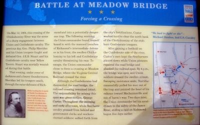
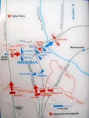
That evening, under cover of darkness and a heavy thunderstorm, Sheridan led his troopers south, through the outer defenses of Richmond and into a potentially dangerous trap. The following morning, the Union commander found himself boxed in with the manned trenches of Richmond’s intermediate defenses in his front, the swollen Chickahominy to his left and Confederate cavalry threatening his rear. To escape, the Union commander chose to force a crossing at Meadow Bridge, where the Virginia Central Railroad crossed the river.
Although the Confederates had dismantled the road bridge, the railroad crossing remained intact. The responsibility for seizing this span was given to Gen. George Custer Throughout the morning and early afternoon, while Southern cavalry pressed from behind and government clerks and workers (turned soldiers) sallied forth from the city’s fortifications, Custer worked hard to clear the north bank of the Chickahominy of the stubborn Confederate troopers.
After gaining a foothold on the Confederate side of the river, Custer’s men kept the Southerners pinned down while Union pioneers repaired the road bridge and planked the railroad span. By 4 p.m., the bridge was open and Union soldiers crossed the swollen stream. Sweeping resistance aside, Sheridan successfully pulled his men out of the trap and pointed the head of his column toward Mechanicsville and out of harm’s way. Two days later, the Union commander led his cavalrymen to the safety of the James River, ending a raid on Richmond begun five days earlier.
“We had to fight or die”
- Michael Donlon, 2nd U.S. Cavalry
Erected by Virginia Civil War Trails.
Topics and series. This historical marker is listed in this topic list: War, US Civil. In addition, it is included in the Virginia Civil War Trails series list. A significant historical date for this entry is May 12, 1864.
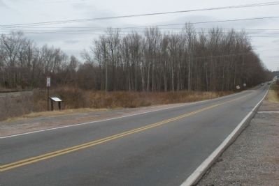
Location. 37° 36.499′ N, 77° 24.775′ W. Marker is near Richmond, Virginia, in Henrico County. Marker is on Richmond Henrico Turnpike, 0.7 miles east of Azalea Avenue. The marker is 100 feet east of the railroad crossing. Richmond Henrico Turnpike becomes Meadowbridge Road on the Hanover County side of the Chickahominy river. Touch for map. Marker is in this post office area: Mechanicsville VA 23116, United States of America. Touch for directions.
Other nearby markers. At least 8 other markers are within 2 miles of this marker, measured
as the crow flies. Old Dominion Building (approx. 1½ miles away); First Lieutenant Jimmie W. Monteith, Jr. (approx. 1.6 miles away); Emek Sholom Holocaust Memorial (approx. 1.7 miles away); The Chickahominy River & Seven Days' Battles (approx. 1.9 miles away); Hanover County / Henrico County (approx. 1.9 miles away); Sheridan's Raid (approx. 1.9 miles away); WWII Memorial Wall (approx. 2 miles away); Seven Days' Battles Begin (approx. 2.1 miles away). Touch for a list and map of all markers in Richmond.
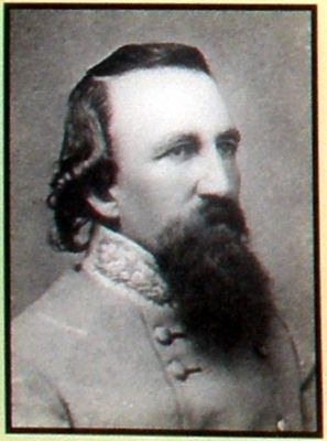
More about this marker. In the lower left is a portrait of General James Gordon. While leading his brigade of North Carolinians in an attack on Sheridan’s rear, Confederate Gen. James B. Gordon was mortally wounded, the second such blow to the Southern cavalry’s high command in as many days.
On the right is a map of the tactical situation described in the text. With Confederates advancing on two sides and his back to the river, Sheridan chose to fight his way across the swollen Chickahominy, abandoning any further designs on Richmond.
Also see . . . Civil War Traveler. Henrico County (Submitted on February 12, 2009, by Bernard Fisher of Richmond, Virginia.)
Credits. This page was last revised on June 16, 2016. It was originally submitted on January 11, 2009, by Bernard Fisher of Richmond, Virginia. This page has been viewed 2,622 times since then and 44 times this year. Photos: 1, 2, 3, 4, 5, 6. submitted on January 11, 2009, by Bernard Fisher of Richmond, Virginia. • Craig Swain was the editor who published this page.
