Winchester, Virginia — The American South (Mid-Atlantic)
The First Battle of Kernstown
Fulkerson’s Virginians Attack!
Photographed By Craig Swain, August 25, 2007
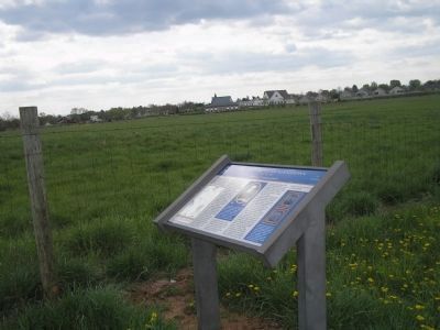
1. The First Battle of Kernstown Marker
A Virtual tour of the Kearnstown battled by HMDb marker
Click for more information.
Click for more information.
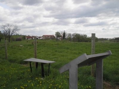
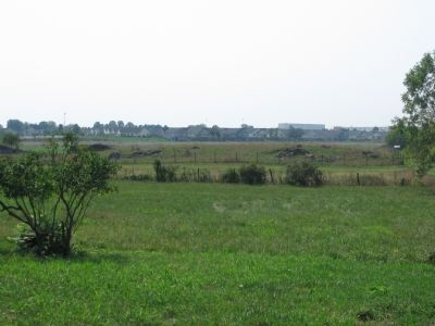
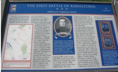
The low, marshy ground stretching from here to the distant road lay uncontested through the five-hour artillery duel that opened the First Battle of Kernstown. The scene changed dramatically at 2:00 P.M. when 900 Virginians marched toward this position from the leafless woods previously standing across the road.
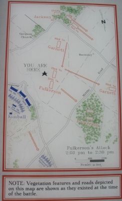
Colonel Samuel V. Fulkerson led this Confederate attack. A lawyer from Abingdon, Virginia, Fulkerson received his orders directly from General “Stonewall” Jackson, who ordered him to “turn a battery of the enemy” on Pritchard’s Hill (the hill directly behind you). To protect his men from the sixteen cannon that opposed him, Fulkerson placed the 37th Virginia and the 23rd Virginia in a formation that spanned 80 yards across and 200 yards deep. With Fulkerson leading his men on a white horse, 600 Virginians paced with him followed by the 33rd Virginia marching 150 yards behind them. As the head of the 37th Virginia passed by this position, the tail of the 33rd Virginia crossed the distant road into this field.
Union artillery fired upon the approaching Virginians, tearing gaping holes into the deep ranks of troops as they marched though the field. When Fulkerson shifted his men to the left, the horror intensified as the Confederate flanks became hopelessly exposed to the unrelenting cannon fire. Unable to reach his destination at the base of Pritchard’s Hill, Fulkerson rushed his men westward across Middle Road (to your right) and up the wooded edge of Sandy Ridge. Perhaps as many as 80 Confederates were killed and wounded in the charge. One company, from Colonel Fulkerson’s hometown, lost 24 men in this daring but fruitless assault.
(Center Sidebar, with portrait of Colonel Samuel V. Fulkerson): Commending his men for fighting “with desperate courage,” Colonel Samuel V. Fulkerson conspicuously led the assault across the fields in front of Pritchard’s Hill. Considered “a great favorite” of “Stonewall” Jackson, Fulkerson’s death at Gaines’ Mill, three months after Kernstown moved Jackson to tears.
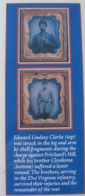
(Right Sidebar, with portraits of the Clarke brothers): Edward Lindsey Clarke (top) was struck in the leg and arm by shell fragments during the charge against Pritchard’s Hill, while his brother Clordoma (bottom) suffered a lesser wound. The brothers, serving in the 23rd Virginia infantry, survived their injuries and the remainder of the war.
Erected by Shenandoah Valley Battlefields National Historic District.
Topics. This historical marker is listed in this topic list: War, US Civil.
Location. This marker has been replaced by another marker nearby. It was located near 39° 8.605′ N, 78° 11.684′ W. Marker was in Winchester, Virginia. Marker could be reached from Battle Park Drive, on the left when traveling west. Located in the Pritchard-Grim Farm, Kernstown Battlefield, to the south of the Omps Farmhouse. Touch for map. Marker was at or near this postal address: 610 Battle Park Drive, Winchester VA 22604, United States of America. Touch for directions.
Other nearby markers. At least 8 other markers are within walking distance of this location. The Pritchard House (about 500 feet away, measured in a direct line); The Second Battle of Kernstown (about 600 feet away); a different marker also named Second Battle of Kernstown (about 600 feet away); a different marker also named The First Battle of Kernstown (about 700 feet away); Kernstown Battlefield (about 800 feet away); Second Battle of Winchester (approx. 0.2 miles away); a different marker also named The Second Battle of Kernstown (approx. 0.2 miles away); a different marker also named The First Battle of Kernstown (approx. ¼ mile away). Touch for a list and map of all markers in Winchester.
More about this marker. The marker also has a map detailing the tactical situation and movements.
Regarding The First Battle of Kernstown. This is one of six battlefield interpretive markers in the park. See the related markers link below for a listing of the walking tour, or the Kernstown Battles Virtual Tour by Markers in the links section for a driving tour.
Related marker. Click here for another marker that is related to this marker. This marker has been replaced by the linked marker.
Also see . . .
1. Kernstown Battlefield Association. Association website homepage (Submitted on August 29, 2007, by Craig Swain of Leesburg, Virginia.)
2. First Battle of Kernstown. From a National Parks Service survey of the Civil War battles in the Shenandoah Valley. (Submitted on August 29, 2007, by Craig Swain of Leesburg, Virginia.)
3. Letters of Colonel Fulkerson. Some of his letters are available online at Virginia Military Institutes's archives. The letters include some references to the Battle of Kernstown and "Stonewall" Jackson's character. (Submitted on August 29, 2007, by Craig Swain of Leesburg, Virginia.)
Credits. This page was last revised on July 9, 2022. It was originally submitted on August 28, 2007, by Craig Swain of Leesburg, Virginia. This page has been viewed 2,268 times since then and 15 times this year. Photos: 1. submitted on August 28, 2007, by Craig Swain of Leesburg, Virginia. 2, 3. submitted on November 26, 2010, by Bill Coughlin of Woodland Park, New Jersey. 4, 5, 6. submitted on August 28, 2007, by Craig Swain of Leesburg, Virginia. • J. J. Prats was the editor who published this page.
