Near Kinston in Lenoir County, North Carolina — The American South (South Atlantic)
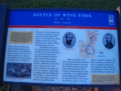
Battle of Wyse Fork
Hoke's Attacks
— Carolinas Campaign —
The Carolinas Campaign began on February 1, 1865, when Union Gen. William T. Sherman led his army north from Savannah, Georgia, after the “March to the Sea.” Sherman’s objective was to join Gen. Ulysses S. Grant in Virginia to crush Gen. Robert E. Lee’s Army of Northern Virginia. Scattered Confederate forces consolidated in North Carolina, the Confederacy’s logistical lifeline, where Sherman defeated Gen. Joseph E. Johnston’s last-ditch attack at Bentonville. After Sherman was reinforced at Goldsboro late in March, Johnston saw the futility of further resistance and surrendered on April 26, essentially ending the Civil War.
Early in March 1865, Union Gen. John M. Schofield began moving from New Bern to Goldsboro, a vital rail junction. His mission was to open railroad communications between the two cities and accumulate supplies for Gen. William T. Sherman, who was marching north to Goldsboro. Schofield ordered Gen. Jacob D. Cox to lead the way. Along Southwest Creek near Kinston, Confederate Gen. Robert F. Hoke’s division blocked Cox’s route.
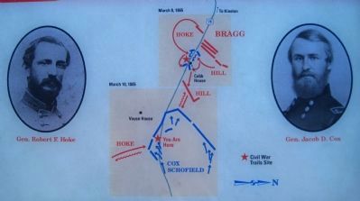
The Federals encountered the Confederates here on March 7, and Hoke struck their left flank the next morning. Confederate Gen. D. H. Hill threatened the Federal right in the afternoon, but Gen. Braxton Bragg, commanding at Kinston, recalled him. Cox received reinforcements late in the day. Action on March 9 was largely limited to skirmishing, as Hoke tested the Federal right flank. Bragg then ordered Hoke to move his division to Lower Trent Troad to attach the Federal rear near Wyse Fork.
Hoke’s men made a cross-country march during the night and launched their assault on the morning of March 10. They encountered a strong skirmish line as well as artillery and fortifications and, after a sharp fight, were unable to break through, despite Hill’s demonstration against the Federal center. Cox’s force held this position as the Confederates retreated to Kinston, fell back to Goldsboro, and then took part in the Battle of Bentonville. After repairing bridges, Schofield occupied Kinston on March 19 and reached Goldsboro two days later.
The yellow sidebar in the lower right of the marker reads:
The house in the distance to your left and front was the home of Confederate Lt. Robert Bond Vause, who was killed at the Battle of Fort Anderson. In 1862, the house was the headquarters of Gen. Robert Ransom, Jr.
Erected by North Carolina Civil War Trails.
Topics. This historical marker is listed in this topic list: War, US Civil. A significant historical month for this entry is February 1811.
Location.
35° 13.077′ N, 77° 30.728′ W. Marker is near Kinston, North Carolina, in Lenoir County. Marker is on New Bern Road (U.S. 70) just west of Wyse Fork Road (County Road 1002), on the right when traveling east. Touch for map. Marker is in this post office area: Kinston NC 28501, United States of America. Touch for directions.
Other nearby markers. At least 8 other markers are within 5 miles of this marker, measured as the crow flies. A different marker also named Battle of Wyse Fork (approx. 1.1 miles away); General Robert Hoke Monument (approx. 1.1 miles away); a different marker also named Battle of Wyse Fork (approx. 1.6 miles away); Confederate Headquarters (approx. 2½ miles away); Battle of Kinston (approx. 4.2 miles away); Lenoir County Confederate Memorial (approx. 4.2 miles away); In Honor and Remembrance (approx. 4.2 miles away); Richard Caswell Gatlin (approx. 4.4 miles away). Touch for a list and map of all markers in Kinston.
More about this marker. This is Wyse Fork Battle Tour Stop #9.
Photographed By Kevin W., October 20, 2009
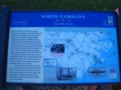
5. North Carolina Civil War Trails Marker
North Carolina’s Civil War stories are as diverse as its landscape. The Outer Banks and coastal rivers saw action early in the war, as Union forces occupied the region. Stories abound of naval battles, blockade running, Federal raids, and the Confederacy’s struggle to supply its armies. Other tales are told in the western mountains, a sometimes-lawless region where Unionists and Confederates fought a war within the war. In the rolling central piedmont, memories linger of Union Gen. William T. Sherman’s relentless march north early in the spring of 1865, when his army defeated the Confederates under Gen. Joseph E. Johnston. Finally, on April 26, Johnston surrendered, essentially ending the Civil War.
Experience these and many more stories as you tour the North Carolina Civil War Trails. Please drive carefully as you visit the sites where ironclads and wooden ships, spies and smugglers, heroes and villains, slaves and soldiers engaged in the greatest conflict in American history.
Experience these and many more stories as you tour the North Carolina Civil War Trails. Please drive carefully as you visit the sites where ironclads and wooden ships, spies and smugglers, heroes and villains, slaves and soldiers engaged in the greatest conflict in American history.
Credits. This page was last revised on March 9, 2021. It was originally submitted on October 29, 2009, by Kevin W. of Stafford, Virginia. This page has been viewed 1,702 times since then and 33 times this year. Photos: 1, 2, 3, 4, 5. submitted on October 29, 2009, by Kevin W. of Stafford, Virginia. • Craig Swain was the editor who published this page.
