Morro Bay in San Luis Obispo County, California — The American West (Pacific Coastal)
The First Landing of Filipinos in the Continental United States
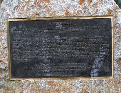
Historic Site
Inscription.
During the Manila-Acapulco Galleon Trade Era from 1565 to 1815 Spanish galleons crossed the Pacific between the Philippines and Mexico.
On October 18, 1587, the Manila Galleon Nuestra Senora de Esperanza commanded by Pedro de Unamuno entered Morro Bay near here. A landing party was sent to shore which included Luzon Indios, marking the first landing of Filipinos in the continental United States. The landing party took official possession of the area for Spain by putting up a cross made of branches. The group was attacked by native Indians two days later, and one of the Filipinos was killed. Unamuno and his crew gave up further exploration of this part of the coast.
Erected 1995 by California Central Coast Chapter of the Filipino American National Historical Society.
Topics. This historical marker is listed in these topic lists: Exploration • Notable Events • Waterways & Vessels. A significant historical month for this entry is October 1704.
Location. 35° 22.334′ N, 120° 51.663′ W. Marker is in Morro Bay, California, in San Luis Obispo County. Marker can be reached from Coleman Drive west of Embarcadero. Touch for map. Marker is in this post office area: Morro Bay CA 93442, United States of America. Touch for directions.
Other nearby markers. At least 8 other markers are within 13 miles of this marker, measured as the crow flies. Morro Rock (approx. ¼ mile away); Cayucos by the Sea (approx. 5.9 miles away); Home of Capt. James Cass (approx. 5.9 miles away); Mustang Memorial Plaza (approx. 12.2 miles away); The Old Powerhouse (approx. 12.2 miles away); Faces of Freedom Veterans Memorial (approx. 12.7 miles away); Chong's Candy Store (approx. 12.8 miles away); Site of Ah Louis Store (approx. 12.8 miles away).
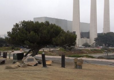
More about this marker. The marker is mounted on a rock near the picnic tables and tree nearest to Coleman Drive in Coleman Park. The park is located only a few hundred yards from Morro Rock, a landmark visible for miles, and so is easy to find.
Also see . . .
1. Did Pedro de Unamuno Really Land in Morro Bay in 1587? Probably Not!. A discussion of the issue of whether the Nuestra Senora de Esperanza actually landed in Morro Bay or at a different location. (Submitted on November 22, 2009.)
2. 422 years ago. Rodel Rodis' article on the Nuestra Senora de Buena Esperanza's landing on the central California coast, offering much more historical detail than is contained

Photographed By Andrew Ruppenstein, September 5, 2008
2. The First Landing of Filipinos in the Continental United States Marker - Wide Shot
This shot of the marker and surroundings, looking east from the marker site, shows the Morro Bay Power Plant in the background. Completed in 1955, the steam electric plant was the first to employee seawater evaporators for the industrial production of fresh water in the US.
Additional keywords. Pinoy
Credits. This page was last revised on October 22, 2020. It was originally submitted on November 22, 2009, by Andrew Ruppenstein of Lamorinda, California. This page has been viewed 2,699 times since then and 116 times this year. Photos: 1, 2, 3. submitted on November 22, 2009, by Andrew Ruppenstein of Lamorinda, California. • Syd Whittle was the editor who published this page.

