Central Business District in Cincinnati in Hamilton County, Ohio — The American Midwest (Great Lakes)
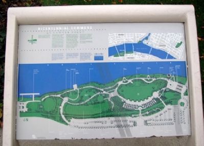
Bicentennial Commons at Sawyer Point
Inscription.
Welcome to a spectacular recreational area created as a gift from the people of Cincinnati to the people of Cincinnati in honor of the city's Bicentennial in 1988.
Originally, this land was an untouched tree-covered bank along a bend in the great river the Indians called “beautiful” or “Ohio”. After settlement was established in 1788, commercial enterprise spread along the river and then inland up into the surrounding hills. The riverfront became one of the nation's leading boat building yards and the terminus of the heavily traveled Miami-Erie Canal system. Its use as an industrial site continued and, by the 1970's everything you now see before you had become an unsightly scrap yard, a blight at the city's front door.
Philanthropist Charles Sawyer made the initial donation to purchase and clear the 22-acre site. This was matched by a Federal Land and Water Conservation Grant and the City of Cincinnati, which in 1980 adopted a plan to develop it as a major public resource. In 1985, the Greater Cincinnati Bicentennial Commission spearheaded the effort to build a recreation complex that would serve generations to come. Thanks to the generous donations of state and local governments and over 500 area businesses and foundations, this one-of-a-kind, world class facility was dedicated on June 4, 1988.
Bicentennial Commons is designed for the common good and use of all members of the community – a meeting place to be shared jointly by the residents of Greater Cincinnati. As such, it offers year-round activities appealing to every age group and interest.
Here is an entire riverfront dedicated to you in celebration of the 200th birthday of your city. Enjoy.
———
You are invited to travel through Ohio River history, starting with the very beginning of time. From the dinosaurs that roamed this valley, to the area's early settlement and tremendous growth, to colorful historical personalities, the Riverwalk illustrates our connection with the river.
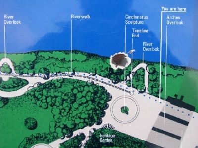
Thirty-three stations along the way tell a captivating story of Greater Cincinnati as the pivotal center of the Ohio River. It begins right here with the extraordinary entrance sculpture where you can explore the many symbols of our rich history.
The four-mile Riverwalk continues along the Ohio riverfront, crosses the river, then wanders along the beautiful Kentucky riverside through historic Covington and Riverboat Row in Newport. Just follow the brightly colored Riverwalk markers for an adventure you will want to return to again and again.
Erected 1988 by Charles Sawyer, the Greater Cincinnati Bicentennial
Commission, the Citizens of Cincinnati, et al.
Topics. This historical marker is listed in these topic lists: Charity & Public Work • Government & Politics • Industry & Commerce • Man-Made Features • Notable Places • Waterways & Vessels. A significant historical month for this entry is June 1790.
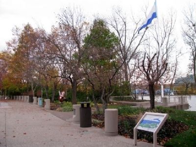
Location. 39° 5.997′ N, 84° 29.949′ W. Marker is in Cincinnati, Ohio, in Hamilton County. It is in the Central Business District. Marker is along the Ohio River in Sawyer Point Park, about 20 feet east of the Newport Southbank pedestrian bridge (former Louisville & Nashville Railroad bridge). Touch for map. Marker is at or near this postal address: 801 East Pete Rose Way, Cincinnati OH 45202, United States of America. Touch for directions.
Other nearby markers. At least 8 other markers are within walking distance of this marker. Lucius Quinctius Cincinnatus (within shouting distance of this marker); 1749 French Claims to Ohio River Valley (within shouting distance of this marker); The Irish in Cincinnati (within shouting distance of this marker); The Sultana (within shouting distance of this marker); Cincinnati's German Heritage (within shouting distance of this marker); The Black Brigade of Cincinnati (within shouting distance of this marker); Corporal Merrill Laws Ricketts Marine Corps Memorial
(approx. ¼ mile away); Ohio’s First Publicly Owned Water System (approx. ¼ mile away). Touch for a list and map of all markers in Cincinnati.
Credits. This page was last revised on February 4, 2023. It was originally submitted on December 17, 2009, by William Fischer, Jr. of Scranton, Pennsylvania. This page has been viewed 2,986 times since then and 156 times this year. Photos: 1, 2, 3. submitted on December 18, 2009, by William Fischer, Jr. of Scranton, Pennsylvania.


