Near Ninety Six in Greenwood County, South Carolina — The American South (South Atlantic)
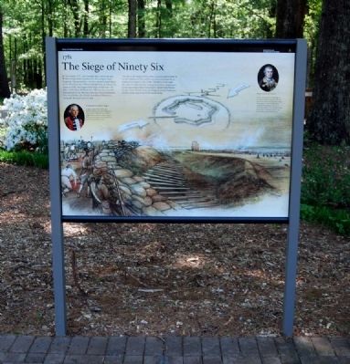
The Siege of Ninety Six
1781
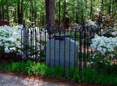
In November 1775 — just months after American and British troops traded musket fire at Lexington and Concord, Massachusetts — the first southern land battle of the Revolutionary War was fought here in Ninety Six. Later, in 1781, the longest field siege of that war — 28 days — took place at Ninety Six. After an unsuccessful final assault by the Patriots, American forces withdrew. One month later, the British abandoned Ninety Six, laying the fort and town to ruin.
The site of the siege of 1781 offers a unique opportunity to see Revolutionary War earthworks and understand how warfare was waged in the 1700s. The story of the siege also offers insight into the strategies used by commanders of the opposing armies: Lieutenant Colonel John Harris Cruger of the British Army and Major General Nathanael Greene of the American Continental Army.
Erected 2009 by National Park Service.
Topics and series. This historical marker is listed in these topic lists: Colonial Era • Forts and Castles • Patriots & Patriotism • War, US Revolutionary. In addition, it is included in the Daughters of the American Revolution series list. A significant historical month for this entry is November 1775.
Location. 34° 8.813′ N, 82° 1.394′ W. Marker is near Ninety Six, South Carolina, in Greenwood County. Marker can be reached from South Cambridge Street (State Highway 248) 1.2 miles south of Johnston Road (State Highway S-24-72), on the left when traveling south. Marker is at the start of a walking trail at a rest area outside the Visitor Center at Ninety Six National Historic Site. Touch for map. Marker is in this post office area: Ninety Six SC 29666, United States of America. Touch for directions.
Other nearby markers. At least 10 other markers are within walking distance of this marker. Ninety Six National Historic Site (here, next to this marker); Ninety Six in the American Revolution (here, next to this marker); Why Is It Called Ninety Six? (here, next to this marker); Walking Tour of the Park (within shouting distance of this marker); Logan Log House (within shouting distance of this marker); a different marker also named Logan Log House (within shouting distance of this marker); 96 (about 300 feet away, measured in a direct line); Monument to James Birmingham (about 400 feet away); James Birmingham (about 400 feet away); Cherokee (about 400 feet away). Touch for a list and map of all markers in Ninety Six.
Also see . . .
1. Ninety Six National Historic Site (U.S. National Park Service). Here settlers struggled against the harsh backcountry to survive, Cherokee Indians hunted and fought to keep their land, two towns and a trading post were formed and abandoned
Photographed By Brian Scott, April 16, 2010
2. The Siege of Ninety Six Marker -
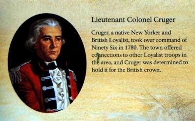
Lieutenant Colonel Cruger
Lieutenant Colonel Cruger
Cruger, a native New Yorker and British Loyalist, took command of Ninety Six in 1780. The town offered connections to other Loyalist troops in the area, and Cruger was determined to hold it for the British crown.
2. Ninety Six National Historic Site. The historic district of Ninety Six National Historic Site contains numerous historical features associated with the economic and social development of the colonial South Carolina back country. (Submitted on May 11, 2010, by Brian Scott of Anderson, South Carolina.)
3. Ninety Six National Historic Site. Ninety Six National Historic Site, also known as Old Ninety Six and Star Fort, is a United States National Historic Site located about 60 miles (96 kilometers) south of Greenville, South Carolina. (Submitted on May 11, 2010, by Brian Scott of Anderson, South Carolina.)
4. Loyalist Institute - Memorial of John Harris Cruger of New York. To the Commissioners appointed by Act of Parliament for enquiring into the Losses & Services of the American Loyalists: The Memorial of Lt. Col. J.,H. Cruger. (Submitted on May 11, 2010, by Brian Scott of Anderson, South Carolina.)
5. Nathanael Greene. Nathanael Greene (August 7, 1742 – June 19, 1786) was a major general of the Continental Army in the American Revolutionary War. (Submitted on May 11, 2010, by Brian Scott of Anderson, South Carolina.)
6. Nathanael Greene Biography. One of the most trusted
Photographed By Brian Scott, April 16, 2010
3. The Siege of Ninety Six Marker -
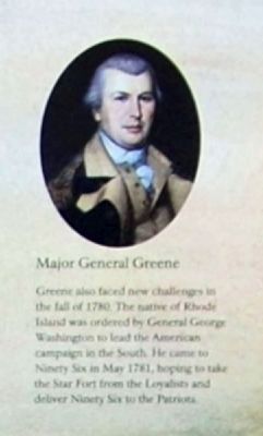
Major General Greene
Major General Greene
Greene also faced new challenges in the fall of 1780. The native of Rhode Island was ordered by General George Washington to lead the American campaign in the South. He came to Ninety Six in May 1781, hoping to take the Star Fort from the Loyalists and deliver Ninety Six to the Patriots.
Additional commentary.
1. Ninety Six National Historic Site
In Greenwood County is the site of the once-flourishing Colonial village of Ninety Six, renamed Cambridge after the Revolution. Even before 1730, the fork lying 96 miles south of the Cherokee Indian town of Keowee was an important post and of Indian and Revolutionary War fortifications, Ninety Six was also a busy courthouse town, its gaol and courthouse described as brick buildings. It has also been described as a "snug little village of 15 or 20 houses and stores." As many as 17 stores were noted at one point...and the population included "4 merchants, as many lawyers, hotel keepers, tailor, blacksmith, carriage and harness shops, and three physicians...there was also belonging to the place a large and well-selected library, and a flourishing academy...there was a church there..."
In the early 1750s, Indian trader Robert Gouedy settled at Ninety Six, his land grant lying astride the Cherokee Path, which later ran through the center of town. Gouedy's store was supposedly the largest house the fall line. Extant from this period is the grave of Gouedy's son, James, in a wooded area south of Star Fort and perhaps near the site of the original Gouedy homeplace.
Gov. William Henry Lyttleton's 1759 expedition built a fort around Gouedy's barn, and this stockade, described as 90' square, provided protection of settlers from a wide surrounding area.
First of the town's Revolutionary fortifications was built in November 1775 at Colonel Savage's plantation, of Savage's Old Field. Separated from Ninety Six courthouse and gaol by a ravine and spring, this was a "temporary stockade fort of fence rails, straws, beeves' hides and other such materials...a square of about 185 yards...the curtains of defense extended from a barn and store to some outhouses; and at a distance of 250 yards from the gaol."
When the British occupied Ninety Six in 1780, they added fortifications to the existing stockade. Major defensive features was a redoubt on the southeast tip of the village. There was Star Fort and it was surrounded by a ditch. Three cannon on wheels strengthened by a stockade, and the gaol was fortified. Further strengthening was added by an embankment of earth surrounding the village and by abatis, a type of defense using felled trees with the branched ends stocking outward. Within the village, blockhouses were erected and covered ways built for safe communication. On the north
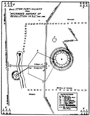
Photographed By National Register Nomination Form
5. Ninety Six and Star Fort
This sketch of ninety Six and Star Fort was published in 1822 in Johnson's Life of Nathanael Green and has since been copied in several publications. Roberts said the design resembled a child's drawing of a seated cat, with the fort as the hear, the village as the body, and the covered passage to the small stockade as the tail.
The 1964 National Survey of Historic Sites and Buildings (Colonials and Patriots) describes Star Fort as "an earthwork with eight salients and eight reentrant angles, enclosing about one-half acre northeast of the village."
This same authority reports that "the Star Fort outlines are still readily discernible as earthwork embankments 4 or 5 feet high. Scattered brick fragments mark the location of the town, which was burned by the British, later rebuilt but lost its court in 1800 and declined in importance. Some identifiable remains include the knoll on which the 1775 siege occurred and on which stood the British stockade fort of 1781, the raving in which flowed the stream supplying water to the garrison, the jail site, the old Charleston Road, and some distance from the village site, the 1759 fortification.
Significance
One of the oldest English place names in upper South Carolina, one
that is significant in South Carolina history and that had a bearing on U.S. history, Ninety Six was of prime importance in upcountry development of the state. Its early history reflects the activity, color, and romance of the typical frontier community of the Colonial era.
The importance of Ninety Six has three distinct phases:
(1) As a trading and meeting junction in colonial years, reflecting South Carolina's Indian and frontier period. On George Hunter's 1730 map of South Carolina's northwest frontier, "96" appears as a special designation on the Cherokee Path, well-traveled pack trail to and from Charleston before 1700. (The original of this map is in the Library of Congress.) Its importance as a trading post is indicated in the 1738 Journal of the House of Assembly. And Gov. James Glen recognized its strategic location be choosing it for his 1746 Indian conference. (This colorful meeting was attended by the S.C. emperor of the Cherokees and 60 of his headmen; accompanying the governor were 4 companies of troops and 200 additional gentlemen.)
(2) As the northwestern area's farthest English settlement from the coast, a thriving Colonial village from as early as 1740 and a busy courthouse town for huge Ninety Six District from 1768 until shortly after 1800. After the 1768 Commons House of Assembly Bill establishing courts, building jails, appointing sheriffs, etc., the development of Ninety Six as a seat of government and justice was part of a significant South Carolina development -- the growing importance of the state overall. Reflected here is the back country struggle for recognition and representation that led to such significant milestones as the establishment of a new capital city in mid-state, beginning in 1786.
During the Colonial period, Ninety Six was a key location in a number of historic expeditions:
(a) Col. George Chicken's 1715 journey inland during the Yemassee War, his journal possible representing the first English account of a Carolina back country traveler and including the only mention of buffalo hereabouts ("we kill'd a boflow this day").
(b) Gov. Glen's 1746 expedition to confer with the Cherokee.
(c) Gov. Lyttleton's 1759 expedition which built, en route, a stockade at Ninety Six that protected area settlers during the 1759-61 Cherokee War. (In March 1760, the garrison withstood a 36-hour Cherokee attack.) Ninety Six also served as a supply center and base of operations for ranger and militia companies and from this time until the Revolution had numerous links with Fort Charlotte, built 1766 on the Savannah River.
(d) The 1775 mission to the back country by William Henry Drayton and the Rev. William Tennett, sent from Charleston by the Council of Safety to explain the American-British disputes and to enlist patriot aid.
(3) As a Revolutionary War stronghold and also as a focal point of violent Patriot-Tory strife. Pre-Revolutionary activity included the raising of a Ranger troop in the Ninety Six area (June 1775) which made the first overt act of the Revolution in South Carolina -- the July 1775 seizure of Fort Charlotte from the British. Ranger commander was James Mayson, who lived near Ninety Six village. In August 1775, Ninety Six sent nine representatives to the Second Provincial Congress. One of these as Commander Mayson.
The Revolution's first land battle south of New England took place at Ninety Six, Nov. 19-12, 1775. Patriot forces, besieged inconclusively, finally defeated and dispersed the Tories in December. In this battle, James Birmingham was the first South Carolina Patriot to give up his life in the Revolution. Andrew Pickens, who later became one of South Carolina's three famous partisan generals, was a company commander in this action.
Old Ninety Six reached the peak of its fame in 1780-81 when it was a British garrison an scene of the siege of Star Fort, one of the most interesting and spectacular operations of the revolutionary's closing months.
In 1779, the British returned to their earlier plan of trying to roll up the states from south to north, and after the 1780 capture of Charleston, ordered three expeditions to the interior to gain control of the state. Ninety Six became important as the most advanced British post, supporting the other two posts, at Augusta and Camden, also covering loyalist settlements and serving as a recruiting depot for Tory fighters.
The Star Fort, built at this time, continued as a British outpost, manned by regulars and Tories, until May-June 1781, when Gen. Nathanael Greene's American force invested and assaulted the fort. The siege was unsuccessful since the fort's star form gave the enemy complete command and exposed the attackers to close cross-fire. Advancing British reinforcements spurred American withdrawal. The British, however, evacuated the fort at the end of the 27-day siege. This relinquishment of the inland South Carolina foothold helped weaken the south-to-north British offensive and was a contributing factor to the war's outcome.
Associated with Old Ninety Six are such historically significant names as Patrick Calhoun (father of John C.), Andrew Pickens, and Sen. John Gervais, who was instrumental in changing the state capital from Charleston.
In post-Revolutionary years, Ninety Six achieved some importance as a college town. Site of one of three colleges authorized by the S.C. General assembly in March 1785, the town changed its name to Cambridge in 1787 in honor of the college. The institution enjoyed no lasting success, however, and by the mid 1820s, the once-flourishing town had almost ceased to exist. (Source: National Register nomination form.)
— Submitted May 11, 2010, by Brian Scott of Anderson, South Carolina.
Credits. This page was last revised on November 20, 2020. It was originally submitted on May 11, 2010, by Brian Scott of Anderson, South Carolina. This page has been viewed 1,662 times since then and 23 times this year. Photos: 1, 2, 3, 4. submitted on May 11, 2010, by Brian Scott of Anderson, South Carolina. 5. submitted on May 9, 2010, by Brian Scott of Anderson, South Carolina. 6. submitted on May 14, 2010, by Brian Scott of Anderson, South Carolina.

