Moncks Corner in Berkeley County, South Carolina — The American South (South Atlantic)
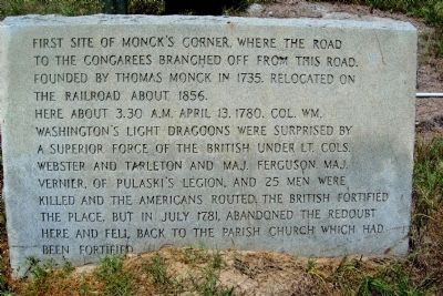
First Site of Moncks Corner
Here about 3:30 A.M. April 13, 1780, Col. Wm. Washington's Light Dragoons were surprised by a superior force of the British under Lt. Cols. Webster and Tarleton and Maj. Ferguson. Maj. Vernier, of Pulaski's Legion, and 25 men were killed and the Americans routed. The British fortified the place, but in July 1781, abandoned the redoubt here and fell back to the parish church which had been fortified.
Topics. This historical marker is listed in these topic lists: Colonial Era • Forts and Castles • Military • Notable Events • Railroads & Streetcars • Settlements & Settlers • War, US Revolutionary. A significant historical month for this entry is April 1922.
Location. 33° 12.187′ N, 79° 59.335′ W. Marker is in Moncks Corner, South Carolina, in Berkeley County. Marker is on U.S. 52 north of North Live Oak Drive (U.S. 17A), on the right when traveling north. Touch for map. Marker is at or near this postal address: 413 North Highway 52, Moncks Corner SC 29461, United States of America. Touch for directions.
Other nearby markers. At least 8 other markers are within 2 miles of this marker, measured as the crow flies. Old Moncks Corner (about 500 feet away, measured in a direct line); Berkeley Training High School (approx. 0.4 miles away); Stony Landing Plantation (approx. half a mile away); Santee Canal (approx. 0.7 miles away); Dixie Training School / Berkeley Training High School (approx. 0.9 miles away); Fairlawn Plantation / Fort Fairlawn (approx. one mile away); a different marker also named Santee Canal (approx. 1.1 miles away); Berkeley County Confederate Monument (approx. 1.1 miles away). Touch for a list and map of all markers in Moncks Corner.
More about this marker. I believe this stone marker may have been placed as far back as the 1930's but I have no proof of that. It was located where the current Historical Marker for Moncks Corner is, at the junction of Highway 17-A and Business Highway 52. The stone marker was relocated to its present location in the 1970's when the metal Historical Marker was installed. This marker gives more information of the history of the American Revolution in Moncks Corner.
Regarding First Site of Moncks Corner. This marker has information about the redoubt built by the British after they captured Moncks Corner. I believe it is the redoubt now referred to as Fort Fairlawn. The capture of Moncks Corner sealed the fate of Charleston which surrendered to the British a month later in May 1780.
Credits. This page was last revised on June 16, 2016. It was originally submitted on July 27, 2010, by Cathi Lee of Moncks Corner, South Carolina. This page has been viewed 2,284 times since then and 199 times this year. Photo 1. submitted on July 27, 2010, by Cathi Lee of Moncks Corner, South Carolina. • Kevin W. was the editor who published this page.
