Hilltop in Columbus in Franklin County, Ohio — The American Midwest (Great Lakes)
The National Road
Side A:
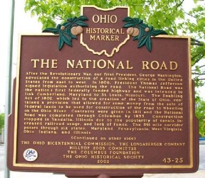
After the Revolutionary War, our first President, George Washington, advocated the construction of a road linking cities in the United States from east to west. In 1806, President Thomas Jefferson signed legislation authorizing the road. The National Road was the nation's first federally funded highway and was intended to link Cumberland, Maryland to St. Louis, Missouri. The Enabling Act of 1802, which led to the creation of the State of Ohio, contained a provision that allowed for some money from the sale of federal lands to be used for construction of the road to Wheeling on the Ohio River. Contracts were given in 1811 and the National Road was completed through Columbus by 1833. Construction stopped in Vandalia, Illinois due to the popularity of canals, increased railroad usage, and lack of funds. The 591 mile corridor passes through six states: Maryland, Pennsylvania, West Virginia, Ohio, Indiana, and Illinois.
(Continued on other side)
Side B:
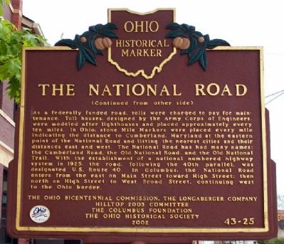
(Continued from other side)
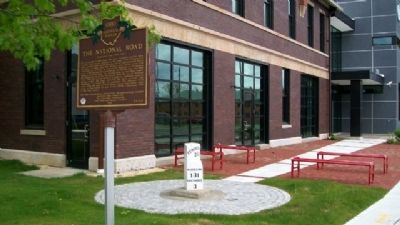
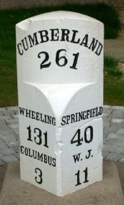
As a federally funded road, tolls were charged to pay for maintenance. Toll houses, designed by the Army Corps of Engineers, were modeled after lighthouses and placed approximately every ten miles. In Ohio, stone Mile Markers were placed every mile indicating the distance to Cumberland, Maryland at the eastern point of the National Road and listing the nearest cities and their distances east and west. The National Road has had many names: the Cumberland Road, the Old National Road, and the Old National Trail. With the establishment of a national numbered highway system in 1925, the road, following the 40th parallel, was designated U.S. Route 40. In Columbus, the National Road enters from the east on Main Street toward High Street; then north on High Street to West Broad Street, continuing west to the Ohio border.
Erected 2002 by Ohio Bicentennial Commission, The Longaberger Company, Hilltop 2003 Committee, The Columbus Foundation, and The Ohio Historical Society. (Marker Number 43-25.)
Topics and series. This historical marker is listed in these topic lists: Communications • Man-Made Features • Roads & Vehicles • Settlements & Settlers. In addition, it is included in the Former U.S. Presidents: #03 Thomas Jefferson, the Ohio Historical Society / The Ohio History Connection, and the The Historic National Road series lists. A significant historical year for this entry is 1806.
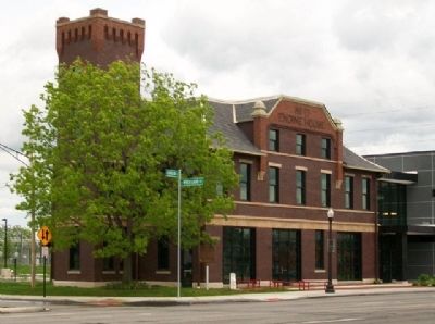
Location. 39° 57.341′ N, 83° 3.705′ W. Marker is in Columbus, Ohio, in Franklin County. It is in Hilltop. Marker is at the intersection of Broad Street and Wheatland Avenue, on the right when traveling west on Broad Street. Touch for map. Marker is at or near this postal address: 2300 West Broad Street, Columbus OH 43204, United States of America. Touch for directions.
Other nearby markers. At least 8 other markers are within 2 miles of this marker, measured as the crow flies. Maynard E. Sensenbrenner (approx. half a mile away); Camp Chase (approx. 0.9 miles away); a different marker also named Camp Chase (approx. 0.9 miles away); a different marker also named Camp Chase (approx. 1.1 miles away); Camp Chase Confederate Cemetery (approx. 1.1 miles away); 2260 Confederate Soldiers (approx. 1.1 miles away); Confederate Cannonball (approx. 1.1 miles away); This Confederate Cemetery (approx. 1.1 miles away). Touch for a list and map of all markers in Columbus.
Also see . . .
1. National Road. Ohio History Central website entry (Submitted on August 6, 2010, by William Fischer, Jr. of Scranton, Pennsylvania.)
2. Historic National Road Scenic Byway, Ohio. Byways website entry (Submitted on August 6, 2010, by William Fischer, Jr. of Scranton, Pennsylvania.)
Credits. This page was last revised on April 2, 2023. It was originally submitted on August 5, 2010, by William Fischer, Jr. of Scranton, Pennsylvania. This page has been viewed 1,785 times since then and 118 times this year. Photos: 1, 2, 3, 4, 5. submitted on August 5, 2010, by William Fischer, Jr. of Scranton, Pennsylvania. 6. submitted on August 27, 2018, by Allen C. Browne of Silver Spring, Maryland.
