Lusby in Calvert County, Maryland — The American Northeast (Mid-Atlantic)
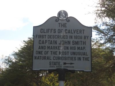
The Cliffs of Calvert
Captain John Smith
and marked on his map.
One of the most unusual
natural curiosities in the
state. →
Erected by State Roads Commission.
Topics. This historical marker is listed in these topic lists: Colonial Era • Natural Features. A significant historical year for this entry is 1608.
Location. 38° 23.715′ N, 76° 26.181′ W. Marker is in Lusby, Maryland, in Calvert County. Marker is on H.G. Trueman Road (Maryland Route 765) 0.6 miles north of Cove Point Road (Maryland Route 497), on the right. Marker is located about 200 feet inside the Calvert Cliffs State park along the entrance way. Touch for map. Marker is in this post office area: Lusby MD 20657, United States of America. Touch for directions.
Other nearby markers. At least 8 other markers are within 4 miles of this marker, measured as the crow flies. Middleham Chapel (approx. ¼ mile away); Morgan Hill Farm (approx. 1.4 miles away); Preston on Patuxent (approx. 1.8 miles away); Cove Point Lighthouse (approx. 3 miles away); Sukeek’s Cabin: A Proud Tradition Lives On (approx. 3.8 miles away); Fate of the Flotilla (approx. 3.8 miles away); Land Battle Evidence (approx. 3.8 miles away); Weapons of War (approx. 3.8 miles away). Touch for a list and map of all markers in Lusby.
Credits. This page was last revised on August 30, 2019. It was originally submitted on November 10, 2007, by F. Robby of Baltimore, Maryland. This page has been viewed 1,888 times since then and 44 times this year. Photos: 1, 2, 3, 4. submitted on November 10, 2007, by F. Robby of Baltimore, Maryland. • J. J. Prats was the editor who published this page.


