Prince Frederick in Calvert County, Maryland — The American Northeast (Mid-Atlantic)
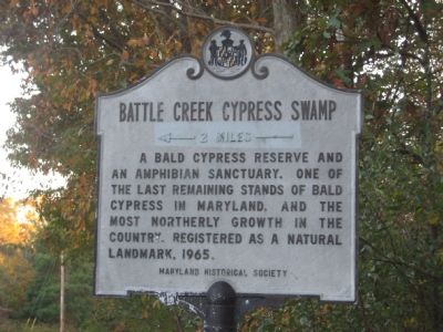
Battle Creek Cypress Swamp
2 miles
Erected by Maryland Historical Society.
Topics. This historical marker is listed in these topic lists: Environment • Natural Features • Natural Resources. A significant historical year for this entry is 1965.
Location. 38° 29.534′ N, 76° 35.394′ W. Marker is in Prince Frederick, Maryland, in Calvert County. Marker is on Grays Road, 0.1 miles south of Sixes Road (Maryland Route 506), on the right when traveling south. Touch for map. Marker is in this post office area: Prince Frederick MD 20678, United States of America. Touch for directions.
Other nearby markers. At least 8 other markers are within 4 miles of this marker, measured as the crow flies. St. John’s Holiness Church (approx. 2.2 miles away); Veitch’s Cove (approx. 2.7 miles away); One-Room School (approx. 2.9 miles away); School #7 (approx. 2.9 miles away); Christ Church (approx. 2.9 miles away); Prince Frederick Library “Firsts” (approx. 3.1 miles away); Panic in Prince Frederick (approx. 3.2 miles away); Veterans Green (approx. 3.2 miles away). Touch for a list and map of all markers in Prince Frederick.
More about this marker. An arrow and “2 Miles” has been whited out on the marker, probably indicating that its original location was at the intersection of Solomons Island Road (MD 2/4) and Sixes Road (MD 506).
Credits. This page was last revised on August 17, 2019. It was originally submitted on November 11, 2007, by F. Robby of Baltimore, Maryland. This page has been viewed 2,360 times since then and 15 times this year. Photos: 1, 2. submitted on November 11, 2007, by F. Robby of Baltimore, Maryland. • J. J. Prats was the editor who published this page.

