Council Grove in Morris County, Kansas — The American Midwest (Upper Plains)
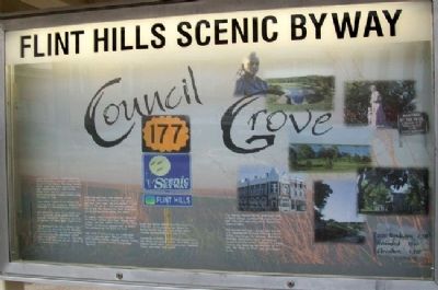
Council Grove
Flint Hills Scenic Byway
Council Grove has been a meeting place for Native Americans, explorers, soldiers and Santa Fe Trail traders. The name "Council Grove" came from treaty negotiations that were conducted here in 1825 between Osage chiefs and U.S. commissioners to grant safe passage to white settlers along the Santa Fe Trail.
Council Grove is noted for its historic and architecturally rich structures. Much of the community is a National Historic District.
Self-guided tour maps are available from local merchants. Group-guided tours are available through the Convention and Visitors Bureau, 212 West Main, Council Grove.
The presence of the Kaw is further highlighted at the Al-le-Ga-Wa-Ho Memorial Heritage Park. Here one can see the ruins of huts built by the government for the Kaw, retrace their steps on the Flint Hills Nature Trail, and learn of their culture at the Heritage Center.
Wah-shun-gah Days, held annually in June, is a family celebration complete with parade, pow-wow, craft show, and flea market. Council Grove is the site of a cutting horse competition in May that displays the skills of national award-winning cutting horses and riders.
In August, Council Grove hosts the "Quilts on the Prairie" outdoor quilt show. During September, you may attend "Voices of the Wind People," an historical pageant that re-enacts the settlement of the Santa Fe Trail.
Just north of Council Grove is a 3,000-acre federal reservoir and a 500-acre city lake. Both facilities provide camping, boating, fishing, picnicking, and other outdoor recreational amenities.
Enjoy the prairie and observe the Santa Fe Trail ruts. Our community and others in Morris County rely upon agriculture - both farming and ranching - as a way of life.
Community activities are centered around farm and family and include church, 4-H clubs, youth rodeos, ranch rodeos, the county fair, livestock shows, and other rural events.
The Kaw (or Kansa) Native Americans lived in three villages southeast of Council Grove until they were moved south to Indian Territory in 1873.
The Kaw Mission was a school built by the U.S. government to teach farming and the "White Man Ways" to the Kaw. Methodist Episcopal missionaries were retained as teachers for the school. Today it is a state historic site depicting the heritage of the Kaw, the Santa Fe Trail, and early Council Grove.
2000 Population: 2,328
Founded: 1847
Elevation: 1,250'
Erected by Flint Hills Scenic Byway.
Topics. This historical marker is listed in these topic lists: Industry & Commerce • Native Americans • Roads & Vehicles • Settlements & Settlers. A significant historical year for this entry is 1825.
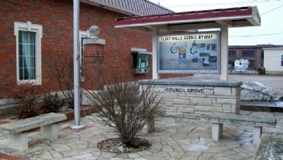
Location. 38° 39.659′ N, 96° 29.409′ W. Marker is in Council Grove, Kansas, in Morris County. Marker is on Main Street (U.S. 56) near Neosho Street (Kansas Highway 177), on the left when traveling west. Touch for map. Marker is at or near this postal address: 131 West Main Street, Council Grove KS 66846, United States of America. Touch for directions.
Other nearby markers. At least 8 other markers are within walking distance of this marker. Malcolm Conn Store (a few steps from this marker); Conn Store (within shouting distance of this marker); Council Grove National Bank Building (within shouting distance of this marker); Farmers & Drovers Bank (within shouting distance of this marker); A Well-furnished Store (within shouting distance of this marker); Hays House (within shouting distance of this marker); Masonic Lodge Hall (within shouting distance of this marker); The Cottage House Hotel and Motel (about 400 feet away, measured in a direct line). Touch for a list and map of all markers in Council Grove.
Also see . . .
1. Council Grove, Kansas. The Flint Hills Life website entry (Submitted on August 2, 2011, by William Fischer, Jr. of Scranton, Pennsylvania.)
2. Our Rich History . City website entry (Submitted on July 25, 2023, by Larry Gertner of New York, New York.)
3. Council Grove, Santa Fe Trail National Historic Landmark. "Kansas Sampler Foundation: 8 Wonders of Kansas History" entry (Submitted on August 2, 2011, by William Fischer, Jr. of Scranton, Pennsylvania.)
4. Santa Fe National Historic Trail. National Park Service website entry (Submitted on August 2, 2011, by William Fischer, Jr. of Scranton, Pennsylvania.)
5. Morris County National and State Registers of Historic Places. Kansas historical Society:
Links to listed sites (Submitted on August 2, 2011, by William Fischer, Jr. of Scranton, Pennsylvania.)
Credits. This page was last revised on July 25, 2023. It was originally submitted on August 2, 2011, by William Fischer, Jr. of Scranton, Pennsylvania. This page has been viewed 533 times since then and 12 times this year. Photos: 1, 2. submitted on August 2, 2011, by William Fischer, Jr. of Scranton, Pennsylvania.

