Fishers Hill in Shenandoah County, Virginia — The American South (Mid-Atlantic)
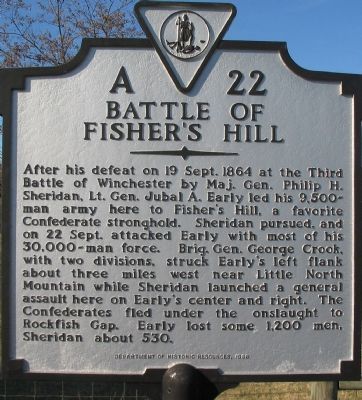
Battle of Fisher's Hill
After his defeat on 19 Sept. 1864 at the Third Battle of Winchester by Maj. Gen. Philip H. Sheridan, Lt. Gen. Jubal A. Early led his 9,500-man army here to Fisher's Hill, a favorite Confederate stronghold. Sheridan pursued, and on 22 Sept. attacked Early with most of his 30,000-man force. Brig. Gen. George Crook, with two divisions, struck Early's left flank about three miles west near Little North Mountain while Sheridan launched a general assault here on Early's center and right. The Confederates fled under the onslaught to Rockfish Gap. Early lost some 1,200 men, Sheridan about 530.
Erected 1998 by Department of Historic Resources. (Marker Number A-22.)
Topics and series. This historical marker is listed in this topic list: War, US Civil. In addition, it is included in the Virginia Department of Historic Resources (DHR) series list. A significant historical date for this entry is September 19, 1864.
Location. 38° 58.456′ N, 78° 24.051′ W. Marker is in Fishers Hill, Virginia, in Shenandoah County. Marker is on Old Valley Pike (U.S. 11), on the right when traveling south. Touch for map. Marker is in this post office area: Fishers Hill VA 22626, United States of America. Touch for directions.
Other nearby markers. At least 8 other markers are within 2 miles of this marker, measured as the crow flies. A different marker also named Battle of Fisher's Hill (about 700 feet away, measured in a direct line); a different marker also named The Battle of Fishers Hill (approx. ¼ mile away); Fisher's Hill Battlefield (approx. 0.7 miles away); a different marker also named Battle of Fisher's Hill (approx. ¾ mile away); Stoner-Keller House & Mill (approx. 0.8 miles away); Creative Women of Fishers Hill (approx. 0.8 miles away); Valley Pike (approx. 0.9 miles away); Ramseur's Hill (approx. 1.3 miles away). Touch for a list and map of all markers in Fishers Hill.
Regarding Battle of Fisher's Hill. This marker replaced a previous A-22 also named Battle of Fisher's Hill which read, "Early took position here after the battle of Winchester, and here he was attacked by Sheridan, September 22, 1864, and forced to retire."
Also see . . . Battle of Fisher's Hill. National Park Service summary of the battle. (Submitted on December 11, 2007, by Craig Swain of Leesburg, Virginia.)

Photographed By Craig Swain
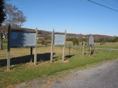
2. Marker Set along the Old Valley Pike
This is one of several markers interpreting the Battle of Fisher's Hill in a virtual tour by HMDb markers.
Click for more information.
Click for more information.

Photographed By Craig Swain, December 1, 2007
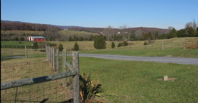
3. Confederate Defensive Line
Looking to the west from the marker, Confederate General John Pegram's division held the high ground in the distance overlooking the South Fork of Tumbling Run. In the valley below is Snapps Run which cut through the Confederate defenses at this point. The ground to the right, and astride the modern day Valley Pike (US 11) was held by General John B. Gordon's division.
Credits. This page was last revised on June 5, 2022. It was originally submitted on December 11, 2007, by Craig Swain of Leesburg, Virginia. This page has been viewed 2,164 times since then and 33 times this year. Last updated on December 9, 2011, by Don Hogan of Milton, Georgia. Photos: 1, 2. submitted on December 11, 2007, by Craig Swain of Leesburg, Virginia. 3. submitted on December 16, 2007, by Craig Swain of Leesburg, Virginia.
