Sanford in Seminole County, Florida — The American South (South Atlantic)
Sanford Railroad Historical Data
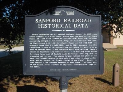
Sanford railroading had its physical beginning January 10, 1880 when former President U. S. Grant broke ground near this spot for the South Florida RR. The South Florida RR operated from 1880-1886, its name successively changed to Jacksonville, Tampa and Key West Ry, 1886-1899, the Plant System 1899-1902, the Atlantic Coast Line RR 1902-1967, the Seaboard Coast Line RR 1967-1980, and in 1980 becoming the CSX Corporation, a union of the Seaboard and the Chessie Systems. With at least 25 railroad trains a day positioned along these facilities, Sanford became an important early railroad center. A 12 mile loop route around the celery farms east of Sanford made it Florida's first city with an integrated rail system. The state's largest railroad ice plant a the Rand Yard allowed farmers to ship celery and other produce nation-wide, making Sanford the "Celery Capital of the World." Today, in 1995 Sanford is the southern terminus of Auto Train. The other side of the marker shows locations of important transportation sites of the 1890s.
(Reverse side):
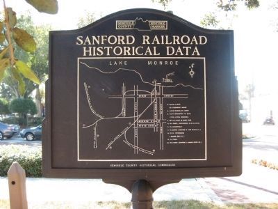
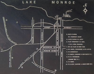
[ Map - (Labeled features are listed below) ]
Lake Monroe, First Street, Seventh Street, Ninth Street, Cedar (Avenue), French Avenue, Oak Avenue, Park Avenue, Jacksonville, Tampa, & Key West Railway, Orange Belt Railway, South Florida Railroad, Sanford & Indian River Railroad
[ Legend ]
1. South Florida RR - Steamboat Wharf (1885)
2. South Florida RR - Depot
3. Plant Investment Co. Bldg. (PICO) (still standing)
4. RR - Ice plant in Rand Yard
5. RR - Shops, Roundhouse & RR Hospital
6. to Jacksonville
7. to Eustis (Sanford & Lake Eustis Ry.)
8. to St. Petersburg (Orange Belt Ry.)
9. to Tampa
10. to Oviedo (Sanford & Indian River RR)
Erected by the Seminole County Historical Commission.
Topics. This historical marker is listed in these topic lists: Agriculture • Railroads & Streetcars • Waterways & Vessels. A significant historical date for this entry is January 10, 1940.
Location. 28° 48.709′ N, 81° 16.2′ W. Marker is in Sanford, Florida, in Seminole County. Marker is at the intersection of West First Street and Myrtle Avenue, on the right when traveling west on West First Street. The marker is in downtown Sanford. Touch for map. Marker is in this post office area: Sanford FL 32771, United States of America. Touch for directions.
Other nearby markers. At least 8 other markers are within walking distance of this marker. The PICO Block (about 400 feet away, measured in a direct line); The PICO Hotel, Restaurant, and Stores (about 600 feet away); The First National Bank No. 1 (about 600 feet away); Rollins College (about 600 feet away); The Henry B. Lord Building (about 600 feet away); The First National Bank No. 2 (about 700 feet away); The Brumley - Puleston Building (about 700 feet away); The DeForest Building (about 800 feet away). Touch for a list and map of all markers in Sanford.
More about this marker. The double-sided marker is capped on both sides with the Seminole County Historic Marker logo.
Regarding Sanford Railroad Historical Data. Sanford has lost much of the extensive, 1890s-era rail system detailed on the marker's map. Railroad facilities like the depot, maintenance shops, roundhouse, hospital, etc., are gone, along with the old steamboat wharf. The train tracks indicated on the map that once wove their way throughout the city have shrunk considerably, with large sections of railway removed once the various railroad companies consolidated and the tracks were deemed unnecessary or undesirable.
Not all the buildings from Sanford's railroad heyday are gone. As noted on the map, the office building built by Henry B. Plant's investment company still stands, and is known as the "PICO block". It is joined by other Plant projects, the PICO Hotel and its adjacent PICO Restaurant
and Stores building, all built to service railroad passengers and business. The PICO buildings have been honored with their own historical markers (see "Other nearby markers" above).
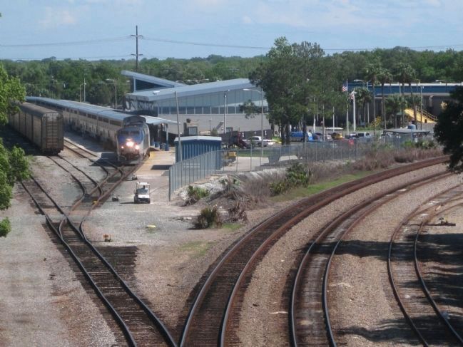
Sanford still holds a prominent role in rail transportation as the home of Amtrak's Auto Train. The Sanford Amtrak station is the southern terminus for Auto Train, which carries passengers and their automobiles north on an overnight, non-stop trip to Lorton, Virginia, just outside Washington, DC.
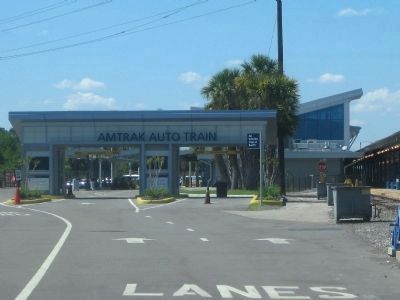
Photographed By AGS Media, March 25, 2012
6. Amtrak Auto Train Station

Photographed By AGS Media, March 25, 2012
7. SunRail - Future site of Sanford Station

Photographed By AGS Media, December 30, 2011
8. Map: Sanford Railroads - 2010s vs. 1890s
Here a photo of the marker's historical railroad map has been edited and topped with a graphic overlay depicting Sanford's current railroad map.
…
Red - red lines indicate existing and current railroad tracks
White - sections of track shown in white only no longer exist
Pink - two pink areas show current/planned train stations
• Amtrak Auto Train Station (rebuilt 2010)
• SunRail Commuter Rail Station (opening 2014)
Red - red lines indicate existing and current railroad tracks
White - sections of track shown in white only no longer exist
Pink - two pink areas show current/planned train stations
• Amtrak Auto Train Station (rebuilt 2010)
• SunRail Commuter Rail Station (opening 2014)
Credits. This page was last revised on July 12, 2018. It was originally submitted on April 1, 2012, by Glenn Sheffield of Tampa, Florida. This page has been viewed 1,489 times since then and 116 times this year. Photos: 1, 2, 3, 4. submitted on April 1, 2012, by Glenn Sheffield of Tampa, Florida. 5, 6, 7, 8. submitted on April 2, 2012, by Glenn Sheffield of Tampa, Florida. • Craig Swain was the editor who published this page.
