Greenbrier West in Chesapeake, Virginia — The American South (Mid-Atlantic)
Planning a Canal
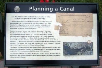
...but plans for a canal at Great Bridge were in place more than three years before the battle. In 1772, the need for trade and commerce with North Carolina led to legislation by the colonial assembly, presided over by Royal Governor Lord Dunmore, to approve the digging of a canal from the Elizabeth River to the North Landing River.
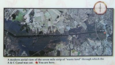
Dunmore authorized surveys and studies to determine if the route should run from the southern or eastern branch of the Elizabeth. Josiah Ives surveyed the southern route in 1772, and canal builder Isaac Hildrith was employed to compare the two routes. Hildrith’s 1775 report noted that the route from Great Bridge “…will pass chiefly through waste lands or such as are of small value, but from the Eastern Branch through such as are or may be cultivated…” The selection of the route was scheduled for “the next Session of General Assembly.” That session was never held. Hildrith later joined Dunmore’s volunteer regiment and helped construct Fort Murray at Great Bridge.
The outbreak of the Revolutionary War and the 1805 opening of the Dismal Swamp Canal delayed construction of the Albemarle & Chesapeake Canal for more than 80 years. When completed in 1859, its course generally followed the 1772 Ives survey.
The project would likely have failed if attempted in 1772 because the removal of an unexpectedly large number of petrified cypress stumps could not have been accomplished without the power of steam.
Erected 2012 by Great Bridge Battlefield & Waterways History Foundation.
Topics. This historical marker is listed in these topic lists: Bridges & Viaducts • War, US Revolutionary • Waterways & Vessels. A significant historical year for this entry is 1772.
Location. 36° 43.262′ N, 76° 14.349′ W. Marker is in Chesapeake, Virginia. It is in Greenbrier West. Marker can be reached from the intersection of North Battlefield Boulevard (Business Virginia Route 168) and Watson Road, on the left when traveling south. Touch for map. Marker is in this post office area: Chesapeake VA 23320, United States of America. Touch for directions.
Other nearby markers. At least 8 other markers are within walking distance of this marker. Battle of Great Bridge DAR Monument (a few steps from this marker); The Marshall Family (within shouting distance of this marker); Great Bridge Marshall Memorial (within shouting distance of this marker); Billy Flora (within shouting distance of this marker); Fort Murray (about 300 feet away, measured in a direct line); Battle of Great Bridge
(about 300 feet away); The Day is Our Own! (about 300 feet away); Liberty to Slaves (about 300 feet away). Touch for a list and map of all markers in Chesapeake.
Also see . . . Great Bridge Battlefield & Waterways History Foundation. (Submitted on April 29, 2012, by Bernard Fisher of Richmond, Virginia.)
Credits. This page was last revised on February 1, 2023. It was originally submitted on April 29, 2012, by Bernard Fisher of Richmond, Virginia. This page has been viewed 665 times since then and 18 times this year. Photos: 1, 2, 3, 4. submitted on April 29, 2012, by Bernard Fisher of Richmond, Virginia.


