Sanford in Seminole County, Florida — The American South (South Atlantic)
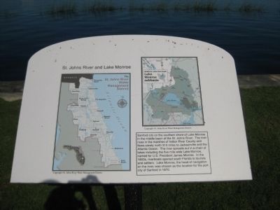
St. Johns River and Lake Monroe
[ Map: The St. Johns River Water Management District - (Labeled features listed below)]
(Counties) Nassau, Duval, Baker, Clay, St. Johns, Bradford, Putnam, Alachua, Flagler, Marion, Volusia, Lake, Seminole, Brevard, Orange, Osceola, Indian River, Okeechobee;
(Cities) Fernandina Beach, Jacksonville, Macclenny, Green Cove Springs, St. Augustine, Gainesville, Palatka, Bunnell, Daytona Beach, Ocala, DeLand, Leesburg, Sanford, Titusville, Orlando, Melbourne, Vero Beach;
Georgia; Atlantic Ocean.
(Map ©) Copyright-St. Johns River Water Management District
[ Map: Middle St. Johns River Basin, Lake Monroe subbasin - (Labeled features listed below)]
(Bodies of water) Lake Monroe, Konomac Lake, Lake Gleason, Dupont Lake, Theresa Lake, Big Lake, Lake Bertha, Lake Jesup, St. Johns River;
(Cities) DeLand, Lake Helen, Deltona, DeBary, Sanford;
(Roadways) Interstate 4; U.S. Route 17/92; State Roads 42, 44, 46, 46A, 415; Howland Boulevard, Doyle Road.
(Map ©) Copyright-St. Johns River Water Management District
Topics. This historical marker is listed in these topic lists: Environment • Waterways & Vessels. A significant historical year for this entry is 1870.
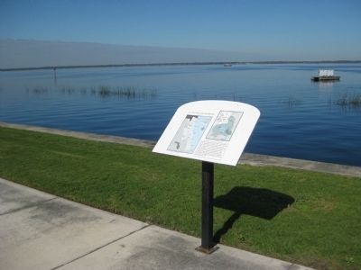
Location. 28° 48.986′ N, 81° 15.878′ W. Marker is in Sanford, Florida, in Seminole County. Marker can be reached from North Palmetto Avenue. The marker stands along the broad, northern edge of Marina Island, on a public sidewalk overlooking Lake Monroe. From where North Palmetto Avenue ends, follow the sidewalk which continues north, then turn right (east) upon reaching the lake. Touch for map. Marker is in this post office area: Sanford FL 32771, United States of America. Touch for directions.
Other nearby markers. At least 8 other markers are within walking distance of this marker. Marina Isle (within shouting distance of this marker); Steamboats (approx. 0.2 miles away); Sanford Est. 1877 (approx. 0.2 miles away); Citrus to Celery (approx. 0.2 miles away); a different marker also named Sanford Est. 1877 (approx. 0.2 miles away); a different marker also named Sanford Est. 1877 (approx. 0.2 miles away); World War II (approx. 0.2 miles away); City of Sanford World War Memorial (approx. 0.2 miles away). Touch for a list and map of all markers in Sanford.
Also see . . .
1. St. Johns River Water Management District. (Submitted on May 16, 2012, by Glenn Sheffield of Tampa, Florida.)
2. Lake Monroe page on SJRWMD website. (Submitted on May 16, 2012, by Glenn Sheffield of Tampa, Florida.)
Credits. This page was last revised on June 16, 2016. It was originally submitted on May 16, 2012, by Glenn Sheffield of Tampa, Florida. This page has been viewed 1,123 times since then and 76 times this year. Photos: 1, 2, 3, 4. submitted on May 16, 2012, by Glenn Sheffield of Tampa, Florida. • Craig Swain was the editor who published this page.


