Weston in Lewis County, West Virginia — The American South (Appalachia)
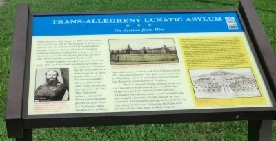
Trans-Allegheny Lunatic Asylum
No Asylum from War
When Virginia seceded from the Union in April 1861, it demanded that funds provided for the asylum’s construction be returned to the state treasury in Richmond to be used for the commonwealth’s defense. Before the order could be carried out, however, the 7th Ohio Volunteer Infantry occupied Weston and removed $27,000 in gold from the Exchange Bank (located in a building that still stands at Bank and Court streets about 300 yards behind you). The gold was transferred to Wheeling, where it was later used to finance the Restored Government of Virginia.
Weston changed hands several times during the war as Federal and then Confederates troops occupied the town for brief periods. Although Confederate raiders confiscated funds and supplies intended for the asylum on two occasions, the hospital was opened to patients in the midst of the war. It became the first civic project of the new state of West Virginia.
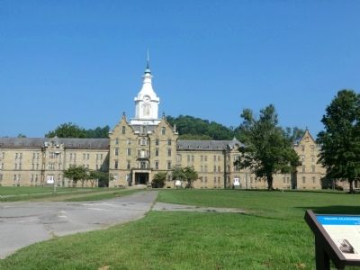
(Sidebar): The Virginia General Assembly authorized the construction of the Trans-Allegheny Lunatic Asylum early in the 1850s. Thomas S. Kirkbride, superintendent of the Pennsylvania Hospital for the Insane, had devised the Kirkbride Plan for such institutions. Utilizing a philosophy called Moral Treatment, Kirkbride theorized that asylum buildings designed to admit abundant light and air could help cure patients. As forbidding as such structures appear to modern eyes, they were considered the epitome of humane treatment at the time. Richard Snowden Andrews, a Baltimore architect, designed this building in the Gothic Revival and Tudor Revival styles. Construction began in 1858, was interrupted by the war, and was not completed until 1881. It is alleged to be the largest building in the nation constructed of hand-cut blue sandstone. The asylum was intended to be largely self-sufficient; a farm, dairy, waterworks, and cemetery were located here. The first patients arrived in 1863. At its peak, in the 1950s, 2,400 patients lived here. The hospital, designated a National Historic Landmark in 1990, closed in 1994.
Erected by West Virginia Civil War Trails.
Topics and series. This historical marker is listed in these topic lists: Science & Medicine • War, US Civil. In addition, it is included in the West Virginia Civil War Trails series list. A significant historical month for this entry is April 1861.
Location. 39° 2.262′ N, 80° 28.2′ W. Marker is in Weston, West Virginia, in Lewis County. Marker is at the intersection of Asylum Drive and South River Avenue, on the right when traveling north on Asylum Drive. Touch for map. Marker is at or near this postal address: 71 Asylum Drive, Weston WV 26452, United States of America. Touch for directions.
Other nearby markers. At least 8 other markers are within walking distance of this marker. Harriet B. Jones (a few steps from this marker); Weston Hospital (about 400 feet away, measured in a direct line); Shirtman (about 400 feet away); Fairland Nickelodeon And Bank Alley (about 500 feet away); Tierney-Farnsworth Building (about 500 feet away); Welcome To Historic Downtown Weston (about 600 feet away); The Second Street Bridge (about 600 feet away); Staunton And Parkersburg Turnpike (about 600 feet away). Touch for a list and map of all markers in Weston.
Credits. This page was last revised on June 16, 2016. It was originally submitted on August 24, 2012, by Don Morfe of Baltimore, Maryland. This page has been viewed 1,056 times since then and 49 times this year. Photos: 1, 2. submitted on August 24, 2012, by Don Morfe of Baltimore, Maryland. • Craig Swain was the editor who published this page.

