Hays in Ellis County, Kansas — The American Midwest (Upper Plains)
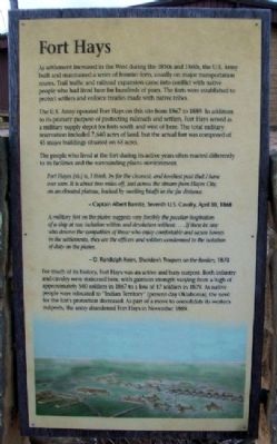
Fort Hays
As settlement increased in the West during the 1850s and 1860s, the U.S. Army built and maintained a series of frontier forts, usually on major transportation routes. Trail traffic and railroad expansion came into conflict with native people who had lived here for hundreds of years. The forts were established to protect settlers and enforce treaties made with native tribes.
The U.S. Army operated Fort Hays on this site from 1867 to 1889. In addition to its primary purpose of protecting railroads and settlers. Fort Hays served as a military supply depot for forts south and west of here. The total military reservation included 7,640 acres of land, but the actual fort was composed of 45 major buildings situated on 65 acres.
The people who lived at the fort during its active years often reacted differently to its facilities and the surrounding plains environment.
Fort Hayes [sic] is, I think, by far the cleanest, and loveliest post that I have ever seen. It is about two miles off, just across the stream from Hayes City, on an elevated plateau, backed by swelling bluffs in the far distance.
- Captain Albert Barnitz, Seventh U.S. Cavalry, April 30, 1868
A military fort on the plains suggests very forcibly the peculiar inspiration of a ship at sea; isolation within and desolation without....If there be any who deserve the sympathies of those who enjoy comfortable and secure homes in the settlements, they are the officers and soldiers condemned to the isolation of duty on the plains.
- D. Randolph Keim, Sheridan's Troopers on the Border, 1870
For much of its history, Fort Hays was an active and busy outpost. Both infantry and cavalry were stationed here, with garrison strength varying from a high of approximately 560 soldiers in 1867 to a low of 17 soldiers in 1879. As native people relocated to "Indian Territory" (present-day Oklahoma), the need for the fort's protection decreased. As part of a move to consolidate its western outposts, the army abandoned Fort Hays in November 1889.
Erected by Kansas Historical Society.
Topics. This historical marker is listed in these topic lists: Forts and Castles • Native Americans • Railroads & Streetcars • Wars, US Indian. A significant historical date for this entry is April 30, 1867.
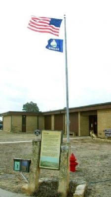
Location. 38° 51.763′ N, 99° 20.584′ W. Marker is in Hays, Kansas, in Ellis County. Marker is on the grounds of Fort Hays State Historic Site, off US Hwy 163 Alternate. Touch for map. Marker is at or near this postal address: 1472 US Highway 163 Alternate, Hays KS 67601, United States of America. Touch for directions.
Other nearby markers. At least 8 other markers are within walking distance of this marker. Fort Hays - Fort Dodge Road Trailhead (within shouting distance
of this marker); Enlisted Barracks (within shouting distance of this marker); Parade Ground (within shouting distance of this marker); Officers' Row (within shouting distance of this marker); Garden (within shouting distance of this marker); Elizabeth Bacon Custer (within shouting distance of this marker); Post Hospital (within shouting distance of this marker); Commissary Warehouse (within shouting distance of this marker). Touch for a list and map of all markers in Hays.
Also see . . .
1. Fort Hays State Historic Site. (Submitted on September 25, 2012, by William Fischer, Jr. of Scranton, Pennsylvania.)
2. Fort Hays at Kansapedia. (Submitted on September 25, 2012, by William Fischer, Jr. of Scranton, Pennsylvania.)
3. Fort Hays National Register Nomination. (Submitted on September 27, 2012, by William Fischer, Jr. of Scranton, Pennsylvania.)
Credits. This page was last revised on September 3, 2020. It was originally submitted on September 25, 2012, by William Fischer, Jr. of Scranton, Pennsylvania. This page has been viewed 544 times since then and 14 times this year. Photos: 1, 2. submitted on September 25, 2012, by William Fischer, Jr. of Scranton, Pennsylvania.

