Near Hodgenville in Larue County, Kentucky — The American South (East South Central)
Slavery in the Valley
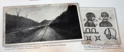
Historians are just beginning to learn about the history of slavery in this area. In addition to the likely presence of slaves on some neighboring farms, the Old Cumberland Trail (today U. S. Hwy. 31E) ran directly beside the Lincoln family farm. It was a main route between Louisville, Kentucky, and Nashville, Tennessee. Some historians believe it was one of the overland routes slave dealers used to transport enslaved African Americans from Kentucky to slave markets farther south.
Lincolnís parents, Thomas and Nancy, attended the Little mount Baptist Church. This church is believed to have been formed by anti-slavery advocates in 1810. It may have been part of a much larger anti-slavery movement within the Baptist churches of Kentucky, beginning in the 1790s. Lincoln later recalled that his fatherís decision to move the family from Kentucky to Indiana was partly due to slavery.
[ Insert - A. Lincoln Quote ]
I am naturally anti-slavery. If slavery is not wrong, nothing is wrong. I cannot remember when I did not so think and feel.
— Abraham Lincoln to Albert Hodges, editor of the Frankfort Commonwealth, April 4, 1864
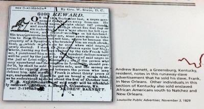
[ Insert - With News Clipping ]
Andrew Barnett, a Greensburg, Kentucky resident, notes in this runaway slave advertisement that he sold his slave, Frank, in New Orleans. Other individuals in this section of Kentucky also sold enslaved African Americans south to Natchez and New Orleans.
Louisville Public Advertiser, November 3, 1829
[ Insert - Photo & Chart ]
( Photo ) - - The Old Cumberland Trail was a main travel artery through this section of Kentucky.
Courtesy of the Lincoln Museum, Fort Wayne, In.
( Chart ) - - An image of slave shackles and restraints, from Thomas Branagan, The Penitential Tyrant, 1807.
Courtesy of the Library of Congress, Prints and photographs Division.
[ Insert on Left Side ]
Kentucky
– ∮ – ∮ – ∮ –
Lincoln
* Heritage Trail *
1809 — Abraham Lincoln born at Sinking Spring Farm, in present-day Larue County, Kentucky.
1816 — Lincoln family moved from Kentucky.
1841 — Abraham Lincoln visited his friend Joshua speed at Farmington, the Speed family plantation, in Louisville, Kentucky.
1842 — Abraham Lincoln married Mary Todd of Lexington, Kentucky.
1847 — The Lincoln family visited Lexington, Kentucky, en route to Abrahamís only term in Congress.
1860 — Abraham Lincoln elected President of the United States in November.
1865 — Abraham Lincoln assassinated at Fordís Theatre in Washington, D.C.
Erected by National Park Service Dept. of the Interior.
Topics and series. This historical marker is listed in these topic lists: Abolition & Underground RR • War, US Civil. In addition, it is included in the Former U.S. Presidents: #16 Abraham Lincoln series list. A significant historical date for this entry is April 4, 1907.
Location. 37° 36.672′ N, 85° 38.294′ W. Marker is near Hodgenville, Kentucky, in Larue County. Marker can be reached from Bardstown Road (U.S. 31E) north of White City Road (Kentucky Route 470), on the left when traveling north. Located to the left at the parking area and buildings at the 'Knob Creek Farm' of Lincoln family. Touch for map. Marker is in this post office area: Hodgenville KY 42748, United States of America. Touch for directions.
Other nearby markers. At least 8 other markers are within 2 miles of this marker, measured as the crow flies. Abraham Lincoln's memory of Knob Creek Farm (here, next to this marker); The Lincoln Tavern (a few steps from this marker); Lincoln Knob Creek Farm (a few steps from this marker); The Lincolns at Knob Creek (within shouting distance of this marker); a different marker also named Lincoln Knob Creek Farm (within shouting distance of this marker); Living Off the Land (within shouting distance of this marker); Abraham Lincoln's First School (approx. 2.1 miles away); Lincoln's Playmate (approx. 2.1 miles away). Touch for a list and map of all markers in Hodgenville.
Credits. This page was last revised on June 16, 2016. It was originally submitted on October 5, 2012, by Al Wolf of Veedersburg, Indiana. This page has been viewed 1,029 times since then and 51 times this year. Photos: 1, 2, 3, 4. submitted on October 5, 2012, by Al Wolf of Veedersburg, Indiana.


