Old Town in Alexandria, Virginia — The American South (Mid-Atlantic)
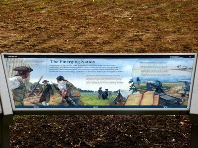
The Emerging Nation
Jones Point Park
— National Park Service, U.S. Department of the Interior —
During the Revolutionary War, cannon positions were established on Jones Point. These defenses were enlarged during and following the War, but eventually abandoned. However, it would not be the military's last use of Jones Point.
The survey that defined the original ten-mile square of the District of Columbia began here when surveyor Andrew Ellicott and Benjamin Banneker, a free black farmer and self taught mathematician and astronomer, placed the south cornerstone on Jones Point in 1791. Although the cornerstone still stands today—located behind the 19th century lighthouse—the land on this side of the Potomac River was returned to Virginia in 1847.
A growing maritime industry brought a ropewalk to Jones Point, which manufactured ship's rope from 1833 to 1850. By 1856, Jones Point also had a lighthouse that guided ship traffic to the bustling ports of Georgetown and Alexandria. When the Civil War began, these points found themselves on opposing sides. Union forces quickly occupied Confederate Alexandria, and in 1863 completed a gun emplacement above Jones Point cove. Along with Forte Foote in Maryland, Battery Rogers guarded the Potomac River approach to the capital.
Erected by National Park Service, U.S. Department of the Interior.
Topics and series. This historical marker is listed in these topic lists: Colonial Era • War, US Civil • War, US Revolutionary. In addition, it is included in the Lighthouses series list. A significant historical year for this entry is 1791.
Location. 38° 47.535′ N, 77° 2.548′ W. Marker is in Alexandria, Virginia. It is in Old Town. Marker can be reached from Jones Point Drive, 0.2 miles South Royal Street, on the right when traveling east. Marker is located near a playground in Jones Point Park. Touch for map. Marker is in this post office area: Alexandria VA 22314, United States of America. Touch for directions.
Other nearby markers. At least 8 other markers are within walking distance of this marker. World Wars to the Present (here, next to this marker); Prehistory to Colonial Settlement (here, next to this marker); The First People on Jones Point (within shouting distance of this marker); A World War I Shipyard Transforms Jones Point (about 300 feet away, measured in a direct line); World War I-Era Rudder (about 300 feet away); Mount Vernon Trail
(about 300 feet away); Potomac Connections (about 400 feet away); Welcome to Jones Point Park (about 400 feet away). Touch for a list and map of all markers in Alexandria.
Related markers. Click here for a list of markers that are related to this marker. These three markers jointly tell the history of Jones Point.
Credits. This page was last revised on January 28, 2023. It was originally submitted on December 21, 2012, by Allen C. Browne of Silver Spring, Maryland. This page has been viewed 780 times since then and 32 times this year. Photos: 1, 2. submitted on December 21, 2012, by Allen C. Browne of Silver Spring, Maryland. • Bernard Fisher was the editor who published this page.

