Buffalo in Dallas County, Missouri — The American Midwest (Upper Plains)
Dallas County
[Front]
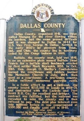
Dallas County, organized 1841, was first called Niangua for the river flowing within its borders, but the name proved difficult and it was changed to Dallas in 1844 for U.S. Vice Pres. George M. Dallas. Settled in the early 1830's by pioneers from Tenn., Ind., and Ohio, the county lies in territory ceded by the Osage Indians in 1808.
Buffalo, the county seat, laid out 1841, is on an extensive plain named Buffalo Head Prairie for a buffalo skull landmark erected by first settler Mark Reynolds, 1833. In Oct., 1863, Gen. Joseph O. Shelby's Confederates burned the courthouse and raiders burned the Methodist Church in July, 1864, then used as a courthouse. A pro-Union county, Dallas suffered numerous guerrilla raids.
In a futile effort to get a railroad, the county issued $235,000 in bonds in 1869-71, and contracted with the Laclede and Fort Scott R.R. Co., for roadbed and bridges. The contract was fulfilled, but the railroad was rerouted to miss the county and it then refused to pay. The debt plus interest rose into millions before it was compromised at $300,000 and finally paid off in 1940.
(See other side)
[Back]
(Continued from other side)
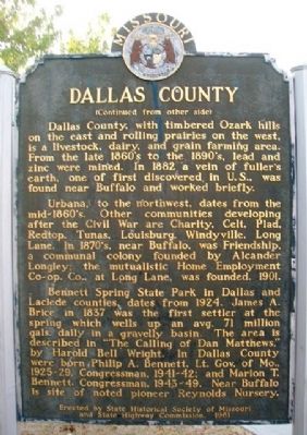
Dallas County, with timbered Ozark hills on the east and rolling prairies on the west, is a livestock, dairy, and grain farming area. From the late 1860's to the 1890's, lead and zinc were mined. In 1882 a vein of fuller's earth, one of first discovered in U.S., was found near Buffalo and worked briefly.
Urbana, to the northwest, dates from the mid-1860's. Other communities developing after the Civil War are Charity, Celt, Plad, Redtop, Tunas, Louisburg, Windyville, Long Lane. In 1870's, near Buffalo, was Friendship, a communal colony founded by Alexander Longley, the mutualistic Home Employment Co-op Co., at Long Lane, was founded, 1901.
Bennett Springs State Park in Dallas and Laclede counties, dates from 1924. James A. Brice in 1837 was the first settler at the spring which wells up an avg. 71 million gals. daily in a gravelly basin. The area is described in "The Calling of Dan Matthews," by Harold Bell Wright. In Dallas County were born Philip A. Bennett, Lt. Gov. of Mo., 1925-29, Congressman, 1941-42; and Marion T. Bennett, Congressman, 1943-49. Near Buffalo is site of noted pioneer Reynolds Nursery.
Erected 1961 by State Historical Society of Missouri and State Highway Commission.
Topics and series. This historical marker is listed in these topic lists: Agriculture • Industry & Commerce • Settlements & Settlers • War, US Civil. In addition, it is included in the Missouri, The State Historical Society of series list. A significant historical month for this entry is July 1864.
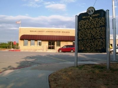
Location. 37° 38.628′ N, 93° 5.502′ W. Marker is in Buffalo, Missouri, in Dallas County. Marker is at the intersection of Cedar Drive and Main Street, on the right when traveling south on Cedar Drive. Marker is at the northeast corner of the county courthouse grounds. Touch for map. Marker is at or near this postal address: 102 South Cedar Drive, Buffalo MO 65622, United States of America. Touch for directions.
Other nearby markers. At least 3 other markers are within 17 miles of this marker, measured as the crow flies. Veterans Memorial (within shouting distance of this marker); Beckner Building (about 300 feet away, measured in a direct line); a different marker also named Veterans Memorial (approx. 16.1 miles away).
Also see . . .
1. Dallas County, Missouri, at Wikipedia. (Submitted on January 11, 2013, by William Fischer, Jr. of Scranton, Pennsylvania.)
2. Dallas County, Missouri, History. (Submitted on January 11, 2013, by William Fischer, Jr. of Scranton, Pennsylvania.)
Credits. This page was last revised on June 16, 2016. It was originally submitted on January 11, 2013, by William Fischer, Jr. of Scranton, Pennsylvania. This page has been viewed 803 times since then and 75 times this year. Photos: 1, 2, 3. submitted on January 11, 2013, by William Fischer, Jr. of Scranton, Pennsylvania.


