Near Albany in Gentry County, Missouri — The American Midwest (Upper Plains)
Gentry County
[Front]
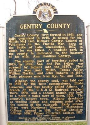
Gentry County, first formed in 1841, and fully organized in 1845, is named for Mo. Militia Maj. Gen. Richard Gentry, Colonel of Volunteers in the Florida War, hero of the Battle of Lake Okeechobee, 1837, in which he was killed. A roadside park in the county is dedicated to the memory of his wife, Ann Hawkins Gentry.
The county, part of territory ceded in 1824 by Iowa, Sac, and Fox tribes, was roamed by Indians into the 1830's. First settlers were Isaac Miller, Tobias Miller, William Martin, and John Roberts in 1834. Early pioneers were from Ky., Va., and Tenn.
Albany, the county seat, was laid out in 1845 by the town commissioner, Elisha Cameron, and was briefly called Athens. A branch of the C. B. & Q. Railroad reached there, 1879, and a second branch was built to a point 2 miles west of town, 1881. The county's largest town, Albany developed as trading center and shipping point after the coming of the railroads. Early schools there were Northwest Missouri (Methodist) College, opened in 1891; Central Christian College, 1892; Palmer (Christian) College, 1912.
(See other side)
[Back]
(Continued from other side)
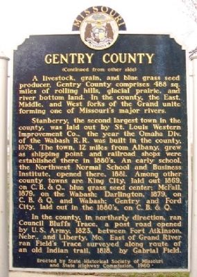
A livestock, grain, and blue grass seed producer, Gentry County comprises 488 sq. miles of rolling hills, glacial prairie, and river bottom land. In the county, the East, Middle, and West forks of the Grand unite forming one of Missouri's major rivers.
Stanberry, the second largest town in the county, was laid out by St. Louis Western Improvement Co., the year the Omaha Div. of the Wabash R.R. was built in the county, 1879. The town, 12 miles from Albany, grew as shipping point and railroad shops were established there in 1880's. An early school, the Northwest Normal School and Business Institute, opened there, 1881. Among other county towns were King City, laid out 1869, on C. B. & Q., blue grass seed center; McFall, 1879, on the Wabash; Darlington, 1879, on C. B. & Q. and Wabash; Gentry and Ford City, laid out in the 1880's, on the C. B. & Q.
In the county, in northerly direction, ran Council Bluffs Trace, a post road opened by U.S. Army, 1823, between Fort Atkinson, Nebr., and Liberty, Mo. East of Grand River ran Field's Trace surveyed along route of an old Indian trail, 1818, by Gabrial Field.
Erected 1960 by State Historical Society of Missouri and State Highway Commission.
Topics and series. This historical marker is listed in these topic lists: Agriculture • Native Americans • Railroads & Streetcars • Settlements & Settlers. In addition, it is included in the Missouri, The State Historical Society of series list. A significant historical year for this entry is 1841.
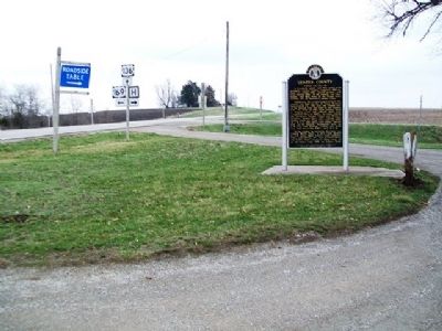
Location. 40° 14.444′ N, 94° 25.626′ W. Marker is near Albany, Missouri, in Gentry County. Marker is at the intersection of U.S. 136/169 and State Route H, on the right when traveling east on U.S. 136/169. Marker is at a roadside pullout. Touch for map. Marker is in this post office area: Albany MO 64402, United States of America. Touch for directions.
Other nearby markers. At least 5 other markers are within 7 miles of this marker, measured as the crow flies. World War Memorial (approx. 5 miles away); War Memorial (approx. 5 miles away); Gentry County Courthouse (approx. 5 miles away); John Jefferson Stansbury (approx. 6.4 miles away); a different marker also named War Memorial (approx. 6.4 miles away).
Also see . . .
1. Gentry County (MO) Courthouse Official Website. (Submitted on July 7, 2013, by William Fischer, Jr. of Scranton, Pennsylvania.)
2. Gentry County (MO) Genealogy. (Submitted on July 7, 2013, by William Fischer, Jr. of Scranton, Pennsylvania.)
3. Gentry County, Missouri at Wikipedia. (Submitted on July 7, 2013, by William Fischer, Jr. of Scranton, Pennsylvania.)
Credits. This page was last revised on June 16, 2016. It was originally submitted on July 7, 2013, by William Fischer, Jr. of Scranton, Pennsylvania. This page has been viewed 788 times since then and 31 times this year. Photos: 1, 2, 3. submitted on July 7, 2013, by William Fischer, Jr. of Scranton, Pennsylvania.


