Near Guernsey in Platte County, Wyoming — The American West (Mountains)
North Platte River

Photographed By Barry Swackhamer, August 23, 2014
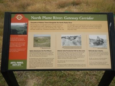
1. North Platte River: Gateway Corridor Marker
Captions: (left to right) Hell Gap; Spanish Diggings; The photograph above shoes where the terrain forced travelers to follow a single path across soft sandstone. Over the years, the sheer volume of the wagon traffic cut ruts so deep into the rock that eventually the wheel hubs left their mark.; J.E. Stimson, Yard Crew at Sunrise.
Currents of History Travel Alongside the North Platte River
Routes along the river originally used by Native Americans were later adopted by fur traders. Beginning as a trickle, waves of wagon train emigrants turned the North Platte River Valley into a major corridor west. Permanent communities came later, and were dependent on the transportation routes that continued to follow the river. The wagon roads, railroads, and eventually a paved highway made settlement possible, contributing to the growth of the North Platte River Valley.
Native Americans: the First Miners
Wyoming’s first inhabitants arrived in this area of Wyoming, known as the Hartville Uplift, approximately 13,500 years ago. They found a variety of food resources and high quality stone for tool making and red ocher pigment.
For thousands of years, Native Americans quarried stone from the famous Spanish Diggings for use in making arrowheads, spear points, scrapers, awls, and other tools. The first Euro-American explorers thought the Spanish developed the quarries in their search for gold, which resulted in the site’s name. Native Americans also mined red ocher, which they traded over long distances and used in both utilitarian and ceremonial ways.
Historic Trails Provide the Path for New Lives
By the mid-1840s, emigrants from all over the world flowed through the North Platte River Valley in search of better lives in the west. Known popularly today as the Oregon Trail, the great overland emigration route laid the path for the Mormons to the Great Salt Lake Valley, for farmers to Oregon’s Willamette Valley, for gold seekers to California, and settlers to many places in-between.
From 1860 through 1861, the Pony Express riders carried their mail along the same trail.
The discovery of gold in the Black Hills of South Dakota in 1874 led to the establishment of the north/south Cheyenne-Deadwood Stage Route.
Railroads Spur Industry
The railroad linked communities and provided the necessary transport of goods, making it possible for local industries to survive. Railroads carried cattle, sheep, iron, and coal to markets.
By 1887, the Cheyenne and Northern Railway reached Hartville Junction near Guernsey.
In 1913, the Chicago, Burlington and Quincy entered Guernsey, eventually becoming the Burlington Northern Santa Fe Railway seen today.
(Side-bar on left)
The Hartville Uplift is home to one of North America’s most significant archaeological sites, the Hell Gap Site.
Northeast of Guernsey, the site provides
archaeologists with an almost complete cultural chronology of America’s oldest inhabitants: the Paleoindians.
Intact, successive occupations uncovered at Hell Gap help to complete the story of the area’s first people.
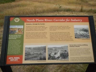
Commerce through the Corridor
Development in the region surrounding this overlook pursued a variety of paths. Following the wave of emigrant migration, open range ranches provided the early commerce for the region.
Eventually, irrigation projects made it possible for numerous farms and small ranches to replace the large ranches. The development of iron mines north of Guernsey in the Hartville and Sunrise areas drove the local economy for nearly a century.
A railroad yard, built to handle the train traffic provided economic stability. Multiple branch lines hauled agricultural and mining goods out of the area to markets.
The local economy diversified during the 1920s and 1930s with the construction and completion of Guernsey Dam in 1927, the development of facilities at Guernsey State Park in the 1930s, and the establishment of Camp Guernsey by the Wyoming National Guard in 1938. These components continue to serve as important elements of the regional economy.
(Side-bar on the left)
The Open Range Closes as Small Ranches and Farms Emerge
In 1902 the Bureau of Reclamation initiated the North Platte Project, an irrigation project designed to supply water to farmers in Wyoming and Nebraska. The project begins at Guernsey and extends 111 miles to the east, watering 390,000 acres through over 2,000 miles of canals, laterals, and drains. This system supplies the Pathfinder Irrigation District and the Goshen Irrigation District with water vital to growing dry beans, corn, alfalfa, potatoes, and sugar beets.
(Side-bar on the bottom)
The Sun Sets on Century-old Mining Activities in Sunrise
The discovery of copper near Hartville in 1881 led to the more important discovery of highly productive iron ores nearby. In 1890 the Colorado Fuel and Iron Company established its operation and built Sunrise, a company town, to support the mine. Sunrise provided a high school, a hospital, and a YMCA, in addition to company houses, a store, and other necessary businesses for the mine workers.
The Sunrise mine closed in 1980 after producing over 40 million tons of iron ore. The town site of Sunrise in now privately owned and largely destroyed. While Hartville experienced an exodus with the closing of the mine, it remains a small, vibrant community.
Erected by Wyoming State Parks & Cultural Resources.
Topics. This historical marker is listed in these topic lists: Industry & Commerce • Native Americans • Roads & Vehicles. A significant historical year for this entry is 1860.
Location. 42° 15.654′ N, 104° 41.839′ W. Marker is near Guernsey, Wyoming, in Platte County. Marker is on U.S. 26,, 1.2 miles east of Wyoming Route 270, on the right when traveling east. Touch for map. Marker is in this post office area: Guernsey WY 82214, United States of America. Touch for directions.
Other nearby markers. At least 8 other markers are within 3 miles of this marker, measured as the crow flies. Lock and Roll Down a Rocky Road (within shouting distance of this marker); Oregon Trail Memorial (approx. 1.1 miles away); Register Cliff (approx. 1.2 miles away); Register Cliff State Historic Site (approx. 1.2 miles away); Centre Star Station (approx. 1.4 miles away); Historic Guernsey Area (approx. 2.3 miles away); Guernsey War Memorial (approx. 2.3 miles away); Oregon Trail (approx. 2.3 miles away). Touch for a list and map of all markers in Guernsey.
More about this marker. This marker is located at the Guernsey Rest Area.
Also see . . .
1. Sunrise, Wyoming - Wyoming Tales and Trail. Sunrise is a company town in the fullest sense. Everthing, and may it be said everybody, is owned by the Colorado Fuel and Iron Company. No special brand is necessary, for the fact impresses itself indelibly on all who come here. Visitors are not especially welcomed, which a glance at the passenger accommodations on the train that meets the Colorado & Southern at Hartville Junction forces itself on all comers. (Submitted on December 22, 2014, by Barry Swackhamer of Brentwood, California.)
2. The “Spanish” Diggings. Sweetwater Now website entry (Submitted on August 25, 2023, by Larry Gertner of New York, New York.)
Credits. This page was last revised on August 25, 2023. It was originally submitted on December 22, 2014, by Barry Swackhamer of Brentwood, California. This page has been viewed 537 times since then and 20 times this year. Last updated on January 16, 2021, by Craig Baker of Sylmar, California. Photos: 1, 2, 3. submitted on December 22, 2014, by Barry Swackhamer of Brentwood, California.

