Waynesboro in Burke County, Georgia — The American South (South Atlantic)
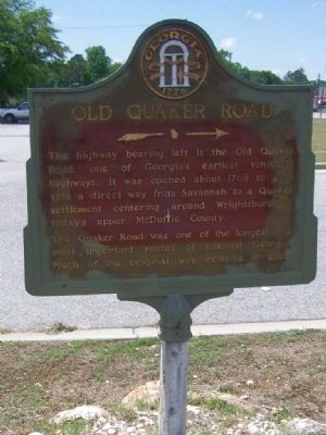
Old Quaker Road
The highway bearing left is the Old Quaker road, on of Georgia's earliest vehicular highways. It was opened about 1769 to provide a direct way from Savannah to a Quaker settlement centering around Wrightsboro in today's upper McDuffie County.
The Quaker road was one of the longest and most important routes of colonial Georgia. Much of the original way remains in use.
Erected 1954 by Georgia Historical Commission. (Marker Number 017-2.)
Topics and series. This historical marker is listed in these topic lists: Colonial Era • Roads & Vehicles • Settlements & Settlers. In addition, it is included in the Georgia Historical Society, and the Quakerism series lists. A significant historical year for this entry is 1769.
Location. 33° 4.728′ N, 82° 0.462′ W. Marker is in Waynesboro, Georgia, in Burke County. Marker is at the intersection of South Liberty Street (State Highway 24) and U.S. 25, on the left when traveling west on South Liberty Street. Touch for map. Marker is in this post office area: Waynesboro GA 30830, United States of America. Touch for directions.
Other nearby markers. At least 8 other markers are within walking distance of this marker. Colonels Twiggs and Few (a few steps from this marker); The Cavalry Actions at Waynesboro (within shouting distance of this marker); The Shadows (approx. 0.8 miles away); The J.D. Roberts Home (approx. 0.8 miles away); To Honor George Washington (approx. 0.9 miles away); Waynesborough (approx. 0.9 miles away); Washington’s Southern Tour (approx. 0.9 miles away); Burke County Veterans Memorial (approx. 0.9 miles away). Touch for a list and map of all markers in Waynesboro.
Credits. This page was last revised on March 22, 2020. It was originally submitted on May 31, 2008, by Mike Stroud of Bluffton, South Carolina. This page has been viewed 1,958 times since then and 42 times this year. Photos: 1, 2. submitted on May 31, 2008, by Mike Stroud of Bluffton, South Carolina. 3. submitted on February 2, 2011, by Mike Stroud of Bluffton, South Carolina. • Kevin W. was the editor who published this page.


