Cody in Park County, Wyoming — The American West (Mountains)
Indian Names for Land Features
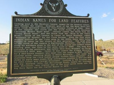
Looking west is the Shoshone Canyon, named for the Shoshoni Indians, who hunted in the region. However, most of the Big Horn Basin had been Crow territory until the Fort Laramie Treaty of 1868. West of the canyon, the north and the south forks of the Shoshone (Stinking Water) Rivers meet. Indians called the North Fork the “Grass House River” and the South Fork the “Rock in the Valley River.” South of the canyon, is Cedar or Spirit Mountain, called “Mountain of Spirits” by the Crow Indians. When the first white settlers arrived in the Cody area in the 1880s, there were Indian burials in trees on the slopes of this mountain. The large peak to the north of the canyon is Rattlesnake Mountain. The red butte along its northern slope is the site of the Arland and Corbett Indian trading post, the first in the area, built in 1880. The long blue mountain to the northwest was called “Blue Bead Mountain” on George Drouillard’s 1809 map. Later, it was named Pat O’Hara Mountain for a well-known trapper, who came into the region in 1853. Looking directly north, standing alone, is Heart Mountain. The name was shortened from the Crow Indian phrase “Buffalo Heart Mountain.” It is shown on early maps, drawn from information supplied in 1807 and 1809 by John Colter and George Drouillard. Looking to the extreme east are big badland hills, the McCullough Peaks, named for Scotsman Pete McCulloch, who trailed one of the first cattle herds into the Big Horn Basin for the Carter Ranch in 1879.
Erected by Rotchford L. Barker and Park County Historical Society.
Topics. This historical marker is listed in these topic lists: Exploration • Native Americans • Natural Features • Settlements & Settlers. A significant historical year for this entry is 1868.
Location. 44° 30.828′ N, 109° 6.308′ W. Marker is in Cody, Wyoming, in Park County. Marker is on W Yellowstone Avenue (U.S. 20) 0.1 miles west of Demaris Drive, on the right when traveling west. Touch for map. Marker is in this post office area: Cody WY 82414, United States of America. Touch for directions.
Other nearby markers. At least 8 other markers are within walking distance of this marker. Old Cody City & Buffalo Bill Cody’s Town in the Rockies (here, next to this marker); Colter’s Hell & Extinct Geyser Basin (here, next to this marker); The Panoramic View (a few steps from this marker); Cedar Mountain (within shouting distance of this marker); Trail to Old Cody City (about 400 feet away, measured in a direct line); Belle Drewry (about 500 feet away); Lee Street – Cody City (about 500 feet away); W.A. Gallagher and Blind Bill (about 500 feet away). Touch for a list and map of all markers in Cody.
Credits. This page was last revised on June 16, 2016. It was originally submitted on August 22, 2015, by Bill Coughlin of Woodland Park, New Jersey. This page has been viewed 544 times since then and 22 times this year. Photos: 1, 2. submitted on August 22, 2015, by Bill Coughlin of Woodland Park, New Jersey. 3, 4. submitted on August 23, 2015, by Bill Coughlin of Woodland Park, New Jersey.


