Jasper in Marion County, Tennessee — The American South (East South Central)
Love's Ferry
Chickamauga Campaign Heritage Trail
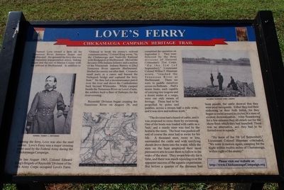
Samuel Love owned a farm on the Tennessee River between Jasper and Shellmound. He operated a ferry that was an important transportation artery, linking Jasper and the rest of Marion County with the railroad at Shellmound. In addition to running the ferry, Love was also the mail carrier. Love's Ferry was a major crossing point used by the Federal Army during the Chickamauga Campaign.
In late August 1863, Colonel Edward King's Brigade of Reynold's Division of the 14th Army Corps occupied Love's Farm. "Ordered to break the enemy's railroad communication," Colonel King wrote, "by the Chattanooga and Nashville Railroad with Bridgeport at Shellmound. Moved the Seventy-fifth Indiana Infantry and a section of the Nineteenth Indiana Battery to (the) Tennessee River opposite Shellmound. Shelled the enemy out after dark. Crossed a small party in a canoe and burned the Nickajack bridge and captured the ferry boat." He then led a reconnaissance patrol over the river and drove the Confederates back beyond Whitesides. While camped beside the Tennessee River on Love's Farm, the soldiers built a fleet of flatboats for the river crossing.
Reynolds' Division began crossing the Tennessee River on August 29, and completed the operation on September 2. They were followed by the three divisions of General Crittenden's 21st Corps. "On the 3rd (of September)," Lieutenant Wilbur F. Hineman wrote, "reached the Tennessee River at Shellmound. There we were to paddle ourselves across on flatboats... Half a dozen boats, each capable of carrying two wagons and a dozen mules at a cargo, were our only means of ferriage. These had to be propelled by poles and paddies, across a stream half a mile wide, and it was slow and tedious work."
"The division had a heard of cattle, and it was proposed to cross them by swimming. One of the boats was loaded with cattle as a 'bait,' and a sturdy steer was tied by the horns to the stern. The boat was pushed off and of course the steer had to swim for his life. A thousand men, more or less, surrounded the cattle and with terrifying shouts drove them into the water, while the men on boat employed their most persuasive arts to coax them to follow in the wake of the steer. They swam bravely for a time, and there was much rejoicing over the apparent success of the aquatic experiment. But before a quarter of the distance had been passed, the cattle showed that they were poor navigators. Either they lost their reckoning or their faith failed, for they began to swim around in circles, in a state of evident demoralization. After floundering for a few minutes they all struck out for the shore from which they had launched. There was no alternative, and they had to be ferried over in squads."
"By noon of the 5th (of September)," Lieutenant Colonel Hineman concluded, "We were in motion again, camping for the night within twelve miles of Chattanooga, within sight of the enemy."
Erected by Chickamauga Campaign Heritage Trail.
Topics. This historical marker is listed in these topic lists: War, US Civil • Waterways & Vessels. A significant historical date for this entry is August 29, 1863.
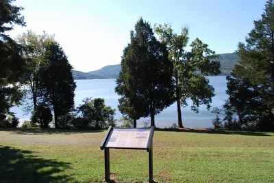
Location. 35° 0.434′ N, 85° 36.55′ W. Marker is in Jasper, Tennessee, in Marion County. Marker can be reached from TVA Road, 2.4 miles south of Interstate 24, on the left when traveling south. Located in the Shellmound Campground next to the bank of the Tennessee River. Touch for map. Marker is at or near this postal address: 2735 TVA Rd, Jasper TN 37347, United States of America. Touch for directions.
Other nearby markers. At least 8 other markers are within 5 miles of this marker, measured as the crow flies. The TVA System of Multipurpose Dams (approx. 0.8 miles away); Civil War in Tennessee (approx. 3.2 miles away); Federal-Georgia Road (approx. 3.7 miles away); Betsy Pack (approx. 4.7 miles away); The Will Cummings Highway (approx. 4.7 miles away); Korean Conflict / Vietnam Conflict (approx. 4.7 miles away); Marion County, Tennessee World War II Memorial (approx. 4.7 miles away); Marion County, Tennessee World War I Memorial (approx. 4.7 miles away). Touch for a list and map of all markers in Jasper.
Also see . . . Chickamauga Campaign Heritage Trail. (Submitted on August 31, 2015, by Brandon Fletcher of Chattanooga, Tennessee.)
Credits. This page was last revised on June 16, 2016. It was originally submitted on August 31, 2015, by Brandon Fletcher of Chattanooga, Tennessee. This page has been viewed 531 times since then and 28 times this year. Photos: 1, 2, 3. submitted on August 31, 2015, by Brandon Fletcher of Chattanooga, Tennessee. • Bernard Fisher was the editor who published this page.


