Piney River in Nelson County, Virginia — The American South (Mid-Atlantic)
The Rivers
The Virginia Blue Ridge Railway Trail
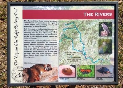
Both rivers begin in the Blue Ridge Mountains and flow eastward. The Piney River (16.5 miles long) is a tributary of the Tye River (35 miles long), which empties into the James River. The rivers form a portion of the boundary between Nelson and Amherst Counties.
The rivers host a wide array of plants and animals, including several threatened and endangered species. Songbirds, waterfowl, hawks and falcons, bats, fox, river otter, beaver, snakes, trout, bass, and several types of butterflies are just some animals that make their homes along the Tye and Piney Rivers. Native plants can also be found along the river banks and include Hemlock, Yellow Birch, Eastern Rough Sedge, and Sharp-toothed Nodding Aster.
(captions)
Eastern Gray Fox Urocyon cinereoargenteneus cinereoargenteneus
Peregrine Falcon Falco peregrinus
Sharp Toothed Nodding Aster Oclemena nemoralis
James River Spinymussel Pleurobema collina
Regal Fritillary Speyeria idalia idalia
Spotted Turtle Clemmys guttata
Erected by Virginia Blue Ridge Railway Trail.
Topics. This historical marker is listed in these topic lists: Animals • Environment • Railroads & Streetcars • Waterways & Vessels.
Location. 37° 40.974′ N, 78° 59.001′ W. Marker is in Piney River, Virginia, in Nelson County. Marker can be reached from Patrick Henry Highway (Virginia Route 151) 0.4 miles south of Firehouse Road (Virginia Route 675), on the left when traveling south. Located along the Virginia Blue Ridge Railway Trail. Touch for map. Marker is at or near this postal address: 3124 Patrick Henry Hwy, Piney River VA 22964, United States of America. Touch for directions.
Other nearby markers. At least 8 other markers are within 4 miles of this marker, measured as the crow flies. Action at Tye River (approx. 2.3 miles away); Hurricane Camille (approx. 2.3 miles away); American Cyanamid (approx. 2.6 miles away); The Virginia Blue Ridge Railway (approx. 2.7 miles away); The Scale House (approx. 2.8 miles away); Cabellsville (approx. 2.9 miles away); The Reverend Robert Rose (approx. 3.6 miles away); Grave of Patrick Henry’s Mother (approx. 3.9 miles away). Touch for a list and map of all markers in Piney River.
Also see . . . Virginia Blue Ridge Railway Trail. (Submitted on March 9, 2016.)
Credits. This page was last revised on June 16, 2016. It was originally submitted on March 9, 2016, by Bernard Fisher of Richmond, Virginia. This page has been viewed 407 times since then and 27 times this year. Photos: 1, 2. submitted on March 9, 2016, by Bernard Fisher of Richmond, Virginia.

